You are here: Home > Network List > S - Seismographs in Schools Projects Stations List
> Station AUPKL Parklands High School, Burnie, TAS > Earthquake Result Viewer
AUPKL Parklands High School, Burnie, TAS - Earthquake Result Viewer
| Earthquake location: |
Sulawesi, Indonesia |
| Earthquake latitude/longitude: |
-1.9/122.6 |
| Earthquake time(UTC): |
2019/04/12 (102) 11:40:49 GMT |
| Earthquake Depth: |
17 km |
| Earthquake Magnitude: |
6.8 Mww |
| Earthquake Catalog/Contributor: |
NEIC PDE/us |
|
| Network: |
S Seismographs in Schools Projects |
| Station: |
AUPKL Parklands High School, Burnie, TAS |
| Lat/Lon: |
41.08 S/145.90 E |
| Elevation: |
171 m |
|
| Distance: |
44.4 deg |
| Az: |
154.636 deg |
| Baz: |
325.504 deg |
| Ray Param: |
0.07193301 |
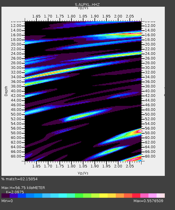
| Estimated Moho Depth: |
56.75 km |
| Estimated Crust Vp/Vs: |
2.10 |
| Assumed Crust Vp: |
6.477 km/s |
| Estimated Crust Vs: |
3.088 km/s |
| Estimated Crust Poisson's Ratio: |
0.35 |
|
| Radial Match: |
82.15854 % |
| Radial Bump: |
400 |
| Transverse Match: |
60.020527 % |
| Transverse Bump: |
400 |
| SOD ConfigId: |
13570011 |
| Insert Time: |
2019-05-02 22:21:34.300 +0000 |
| GWidth: |
2.5 |
| Max Bumps: |
400 |
| Tol: |
0.001 |
|

Signal To Noise
| Channel | StoN | STA | LTA |
| S:AUPKL: :HHZ:20190412T11:48:28.409987Z | 5.5967 | 2.0796647E-6 | 3.7158765E-7 |
| S:AUPKL: :HHN:20190412T11:48:28.409987Z | 1.9958142 | 7.821731E-7 | 3.9190678E-7 |
| S:AUPKL: :HHE:20190412T11:48:28.409987Z | 1.6061387 | 7.0747024E-7 | 4.404789E-7 |
| Arrivals |
| Ps | 10 SECOND |
| PpPs | 26 SECOND |
| PsPs/PpSs | 36 SECOND |


