You are here: Home > Network List > TA - USArray Transportable Network (new EarthScope stations) Stations List
> Station D28M Stokes Point, YT, CAN > Earthquake Result Viewer
D28M Stokes Point, YT, CAN - Earthquake Result Viewer
| Earthquake location: |
Sulawesi, Indonesia |
| Earthquake latitude/longitude: |
-1.9/122.6 |
| Earthquake time(UTC): |
2019/04/12 (102) 11:40:49 GMT |
| Earthquake Depth: |
17 km |
| Earthquake Magnitude: |
6.8 Mww |
| Earthquake Catalog/Contributor: |
NEIC PDE/us |
|
| Network: |
TA USArray Transportable Network (new EarthScope stations) |
| Station: |
D28M Stokes Point, YT, CAN |
| Lat/Lon: |
69.33 N/138.74 W |
| Elevation: |
32 m |
|
| Distance: |
94.8 deg |
| Az: |
20.624 deg |
| Baz: |
277.502 deg |
| Ray Param: |
0.04094621 |
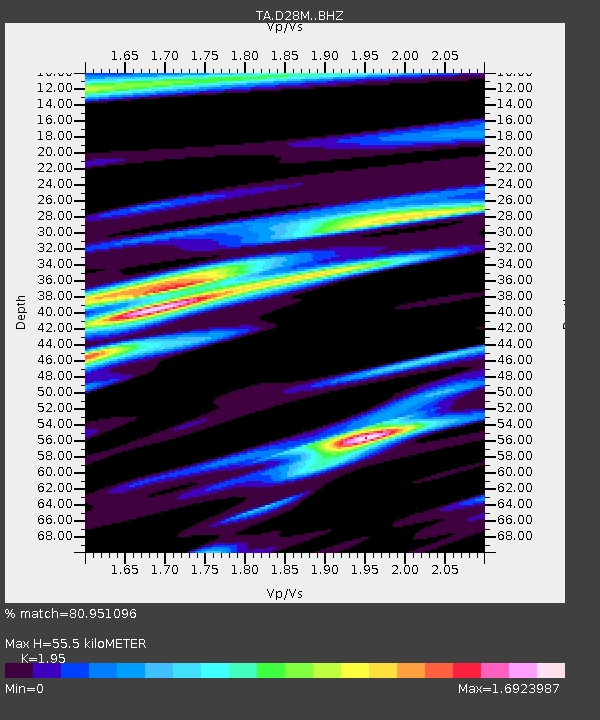
| Estimated Moho Depth: |
55.5 km |
| Estimated Crust Vp/Vs: |
1.95 |
| Assumed Crust Vp: |
6.316 km/s |
| Estimated Crust Vs: |
3.239 km/s |
| Estimated Crust Poisson's Ratio: |
0.32 |
|
| Radial Match: |
80.951096 % |
| Radial Bump: |
400 |
| Transverse Match: |
81.41852 % |
| Transverse Bump: |
374 |
| SOD ConfigId: |
13570011 |
| Insert Time: |
2019-05-02 22:21:51.297 +0000 |
| GWidth: |
2.5 |
| Max Bumps: |
400 |
| Tol: |
0.001 |
|

Signal To Noise
| Channel | StoN | STA | LTA |
| TA:D28M: :BHZ:20190412T11:53:38.800001Z | 2.3844502 | 6.489802E-7 | 2.7217183E-7 |
| TA:D28M: :BHN:20190412T11:53:38.800001Z | 2.0009882 | 4.2324967E-7 | 2.1152033E-7 |
| TA:D28M: :BHE:20190412T11:53:38.800001Z | 1.0352014 | 2.6574193E-7 | 2.5670553E-7 |
| Arrivals |
| Ps | 8.5 SECOND |
| PpPs | 25 SECOND |
| PsPs/PpSs | 34 SECOND |


