You are here: Home > Network List > TA - USArray Transportable Network (new EarthScope stations) Stations List
> Station E17K Hotham Inlet, AK, USA > Earthquake Result Viewer
E17K Hotham Inlet, AK, USA - Earthquake Result Viewer
| Earthquake location: |
Sulawesi, Indonesia |
| Earthquake latitude/longitude: |
-1.9/122.6 |
| Earthquake time(UTC): |
2019/04/12 (102) 11:40:49 GMT |
| Earthquake Depth: |
17 km |
| Earthquake Magnitude: |
6.8 Mww |
| Earthquake Catalog/Contributor: |
NEIC PDE/us |
|
| Network: |
TA USArray Transportable Network (new EarthScope stations) |
| Station: |
E17K Hotham Inlet, AK, USA |
| Lat/Lon: |
67.08 N/161.83 W |
| Elevation: |
233 m |
|
| Distance: |
86.1 deg |
| Az: |
22.349 deg |
| Baz: |
256.025 deg |
| Ray Param: |
0.044265103 |
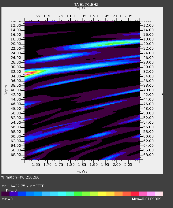
| Estimated Moho Depth: |
32.75 km |
| Estimated Crust Vp/Vs: |
1.60 |
| Assumed Crust Vp: |
6.276 km/s |
| Estimated Crust Vs: |
3.922 km/s |
| Estimated Crust Poisson's Ratio: |
0.18 |
|
| Radial Match: |
96.230286 % |
| Radial Bump: |
342 |
| Transverse Match: |
83.48781 % |
| Transverse Bump: |
400 |
| SOD ConfigId: |
13570011 |
| Insert Time: |
2019-05-02 22:21:51.587 +0000 |
| GWidth: |
2.5 |
| Max Bumps: |
400 |
| Tol: |
0.001 |
|

Signal To Noise
| Channel | StoN | STA | LTA |
| TA:E17K: :BHZ:20190412T11:52:58.250014Z | 9.312851 | 1.3601543E-6 | 1.4605133E-7 |
| TA:E17K: :BHN:20190412T11:52:58.250014Z | 1.7826144 | 2.6515764E-7 | 1.4874648E-7 |
| TA:E17K: :BHE:20190412T11:52:58.250014Z | 2.7644744 | 3.2506017E-7 | 1.1758479E-7 |
| Arrivals |
| Ps | 3.2 SECOND |
| PpPs | 13 SECOND |
| PsPs/PpSs | 16 SECOND |


