You are here: Home > Network List > TA - USArray Transportable Network (new EarthScope stations) Stations List
> Station 125A Gardner Draw, Artesia, NM, USA > Earthquake Result Viewer
125A Gardner Draw, Artesia, NM, USA - Earthquake Result Viewer
| Earthquake location: |
Tonga Islands |
| Earthquake latitude/longitude: |
-16.3/-173.5 |
| Earthquake time(UTC): |
2009/10/02 (275) 01:07:39 GMT |
| Earthquake Depth: |
8.0 km |
| Earthquake Magnitude: |
6.1 MB, 6.0 MS, 6.1 MW, 6.1 MW |
| Earthquake Catalog/Contributor: |
WHDF/NEIC |
|
| Network: |
TA USArray Transportable Network (new EarthScope stations) |
| Station: |
125A Gardner Draw, Artesia, NM, USA |
| Lat/Lon: |
32.66 N/104.66 W |
| Elevation: |
1212 m |
|
| Distance: |
81.8 deg |
| Az: |
52.622 deg |
| Baz: |
244.754 deg |
| Ray Param: |
0.047334086 |
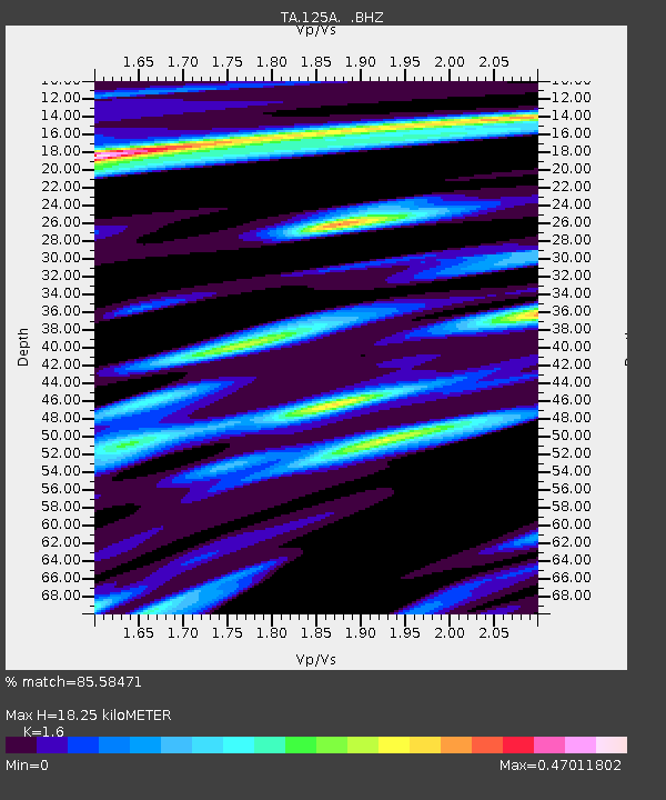
| Estimated Moho Depth: |
18.25 km |
| Estimated Crust Vp/Vs: |
1.60 |
| Assumed Crust Vp: |
6.232 km/s |
| Estimated Crust Vs: |
3.895 km/s |
| Estimated Crust Poisson's Ratio: |
0.18 |
|
| Radial Match: |
85.58471 % |
| Radial Bump: |
304 |
| Transverse Match: |
66.44029 % |
| Transverse Bump: |
359 |
| SOD ConfigId: |
2622 |
| Insert Time: |
2010-03-06 21:28:30.845 +0000 |
| GWidth: |
2.5 |
| Max Bumps: |
400 |
| Tol: |
0.001 |
|
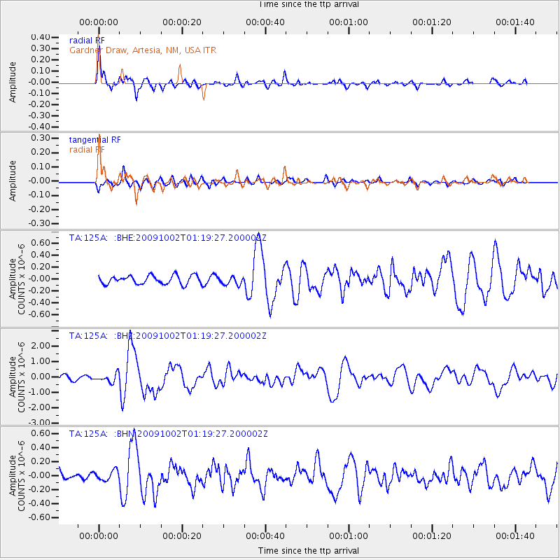
Signal To Noise
| Channel | StoN | STA | LTA |
| TA:125A: :BHZ:20091002T01:19:27.200002Z | 1.8710102 | 2.7661318E-7 | 1.478416E-7 |
| TA:125A: :BHN:20091002T01:19:27.200002Z | 0.6577778 | 7.213605E-8 | 1.0966629E-7 |
| TA:125A: :BHE:20091002T01:19:27.200002Z | 0.9670611 | 6.85736E-8 | 7.090927E-8 |
| Arrivals |
| Ps | 1.8 SECOND |
| PpPs | 7.4 SECOND |
| PsPs/PpSs | 9.2 SECOND |


