You are here: Home > Network List > TA - USArray Transportable Network (new EarthScope stations) Stations List
> Station G21K Allakaket, AK, USA > Earthquake Result Viewer
G21K Allakaket, AK, USA - Earthquake Result Viewer
| Earthquake location: |
Sulawesi, Indonesia |
| Earthquake latitude/longitude: |
-1.9/122.6 |
| Earthquake time(UTC): |
2019/04/12 (102) 11:40:49 GMT |
| Earthquake Depth: |
17 km |
| Earthquake Magnitude: |
6.8 Mww |
| Earthquake Catalog/Contributor: |
NEIC PDE/us |
|
| Network: |
TA USArray Transportable Network (new EarthScope stations) |
| Station: |
G21K Allakaket, AK, USA |
| Lat/Lon: |
66.52 N/153.51 W |
| Elevation: |
446 m |
|
| Distance: |
89.3 deg |
| Az: |
23.488 deg |
| Baz: |
263.712 deg |
| Ray Param: |
0.041965496 |
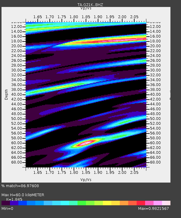
| Estimated Moho Depth: |
60.0 km |
| Estimated Crust Vp/Vs: |
1.85 |
| Assumed Crust Vp: |
6.455 km/s |
| Estimated Crust Vs: |
3.499 km/s |
| Estimated Crust Poisson's Ratio: |
0.29 |
|
| Radial Match: |
86.97608 % |
| Radial Bump: |
400 |
| Transverse Match: |
72.640495 % |
| Transverse Bump: |
400 |
| SOD ConfigId: |
13570011 |
| Insert Time: |
2019-05-02 22:22:10.457 +0000 |
| GWidth: |
2.5 |
| Max Bumps: |
400 |
| Tol: |
0.001 |
|

Signal To Noise
| Channel | StoN | STA | LTA |
| TA:G21K: :BHZ:20190412T11:53:13.300001Z | 2.0949147 | 5.565697E-7 | 2.6567656E-7 |
| TA:G21K: :BHN:20190412T11:53:13.300001Z | 0.86069435 | 1.7935912E-7 | 2.0838888E-7 |
| TA:G21K: :BHE:20190412T11:53:13.300001Z | 1.5209613 | 2.1162711E-7 | 1.3914037E-7 |
| Arrivals |
| Ps | 8.0 SECOND |
| PpPs | 26 SECOND |
| PsPs/PpSs | 34 SECOND |


