You are here: Home > Network List > TA - USArray Transportable Network (new EarthScope stations) Stations List
> Station H31M Peel River, Yukon, CAN > Earthquake Result Viewer
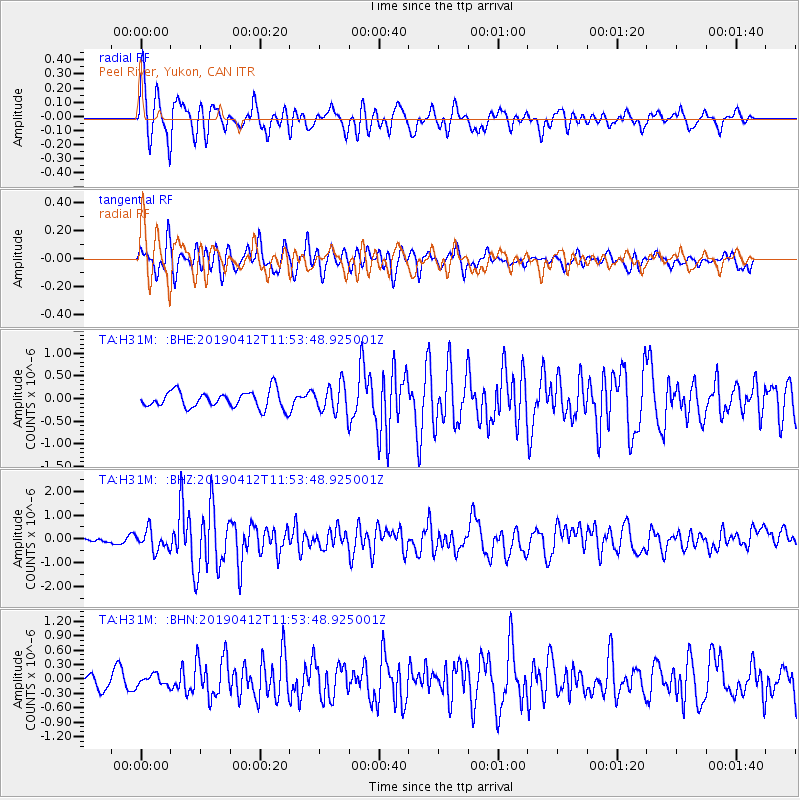
H31M Peel River, Yukon, CAN - Earthquake Result Viewer
*The percent match for this event was below the threshold and hence no stack was calculated.
| Earthquake location: |
Sulawesi, Indonesia |
| Earthquake latitude/longitude: |
-1.9/122.6 |
| Earthquake time(UTC): |
2019/04/12 (102) 11:40:49 GMT |
| Earthquake Depth: |
17 km |
| Earthquake Magnitude: |
6.8 Mww |
| Earthquake Catalog/Contributor: |
NEIC PDE/us |
|
| Network: |
TA USArray Transportable Network (new EarthScope stations) |
| Station: |
H31M Peel River, Yukon, CAN |
| Lat/Lon: |
65.81 N/134.34 W |
| Elevation: |
642 m |
|
| Distance: |
97.0 deg |
| Az: |
23.857 deg |
| Baz: |
281.228 deg |
| Ray Param: |
$rayparam |
*The percent match for this event was below the threshold and hence was not used in the summary stack. |
|
| Radial Match: |
75.092064 % |
| Radial Bump: |
400 |
| Transverse Match: |
70.56953 % |
| Transverse Bump: |
400 |
| SOD ConfigId: |
13570011 |
| Insert Time: |
2019-05-02 22:22:23.848 +0000 |
| GWidth: |
2.5 |
| Max Bumps: |
400 |
| Tol: |
0.001 |
|
Signal To Noise
| Channel | StoN | STA | LTA |
| TA:H31M: :BHZ:20190412T11:53:48.925001Z | 2.8562622 | 4.225822E-7 | 1.4794936E-7 |
| TA:H31M: :BHN:20190412T11:53:48.925001Z | 0.4100532 | 1.11945134E-7 | 2.730015E-7 |
| TA:H31M: :BHE:20190412T11:53:48.925001Z | 1.6622603 | 3.1202825E-7 | 1.8771323E-7 |
| Arrivals |
| Ps | |
| PpPs | |
| PsPs/PpSs | |


