You are here: Home > Network List > TA - USArray Transportable Network (new EarthScope stations) Stations List
> Station 125A Gardner Draw, Artesia, NM, USA > Earthquake Result Viewer
125A Gardner Draw, Artesia, NM, USA - Earthquake Result Viewer
| Earthquake location: |
Tonga Islands Region |
| Earthquake latitude/longitude: |
-23.0/-174.7 |
| Earthquake time(UTC): |
2009/03/19 (078) 18:17:40 GMT |
| Earthquake Depth: |
34 km |
| Earthquake Magnitude: |
7.0 MB, 7.6 MS, 7.6 MW, 7.6 MW |
| Earthquake Catalog/Contributor: |
WHDF/NEIC |
|
| Network: |
TA USArray Transportable Network (new EarthScope stations) |
| Station: |
125A Gardner Draw, Artesia, NM, USA |
| Lat/Lon: |
32.66 N/104.66 W |
| Elevation: |
1212 m |
|
| Distance: |
86.8 deg |
| Az: |
52.556 deg |
| Baz: |
240.11 deg |
| Ray Param: |
0.04377897 |
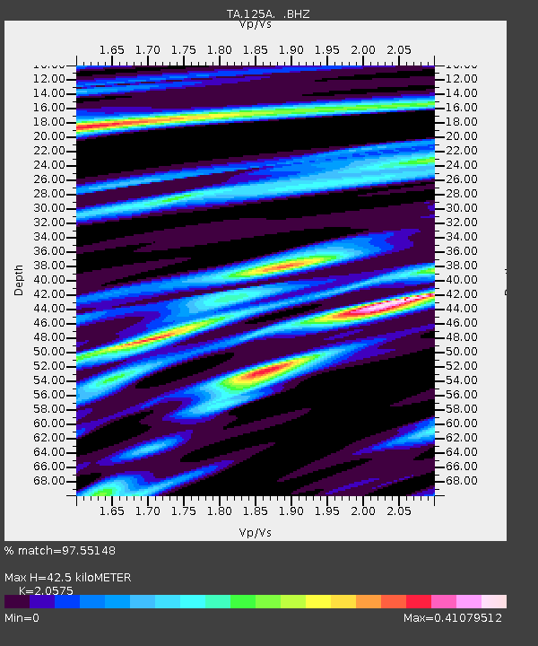
| Estimated Moho Depth: |
42.5 km |
| Estimated Crust Vp/Vs: |
2.06 |
| Assumed Crust Vp: |
6.232 km/s |
| Estimated Crust Vs: |
3.029 km/s |
| Estimated Crust Poisson's Ratio: |
0.35 |
|
| Radial Match: |
97.55148 % |
| Radial Bump: |
400 |
| Transverse Match: |
94.37237 % |
| Transverse Bump: |
400 |
| SOD ConfigId: |
2658 |
| Insert Time: |
2010-03-06 21:28:44.674 +0000 |
| GWidth: |
2.5 |
| Max Bumps: |
400 |
| Tol: |
0.001 |
|
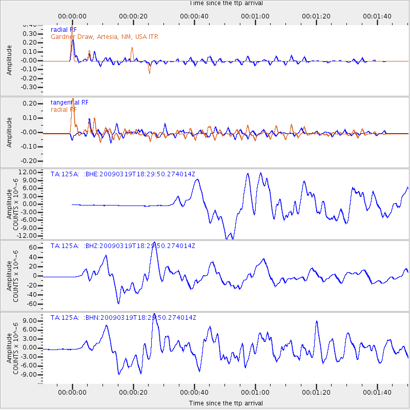
Signal To Noise
| Channel | StoN | STA | LTA |
| TA:125A: :BHZ:20090319T18:29:50.274014Z | 25.186234 | 6.8810546E-6 | 2.7320695E-7 |
| TA:125A: :BHN:20090319T18:29:50.274014Z | 9.184929 | 1.083574E-6 | 1.1797305E-7 |
| TA:125A: :BHE:20090319T18:29:50.274014Z | 10.049542 | 1.2884146E-6 | 1.282063E-7 |
| Arrivals |
| Ps | 7.3 SECOND |
| PpPs | 20 SECOND |
| PsPs/PpSs | 28 SECOND |


