You are here: Home > Network List > TA - USArray Transportable Network (new EarthScope stations) Stations List
> Station L14K Kuka Creek, AK, USA > Earthquake Result Viewer
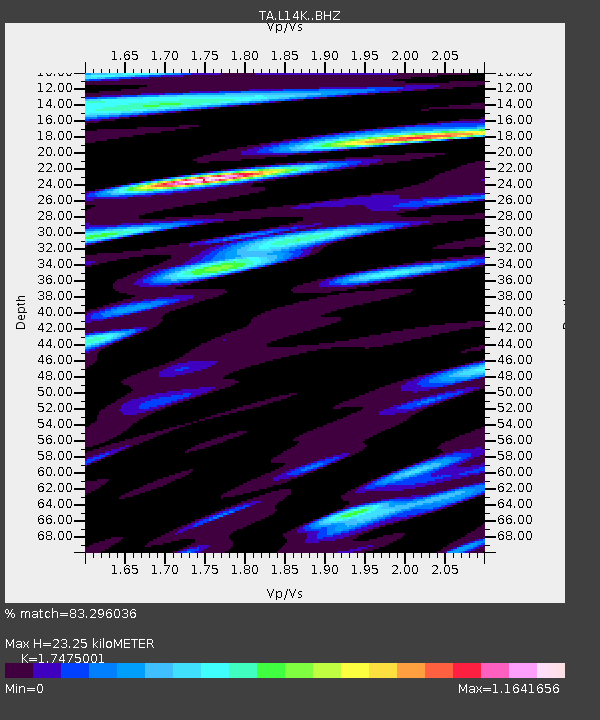
L14K Kuka Creek, AK, USA - Earthquake Result Viewer
| Earthquake location: |
Sulawesi, Indonesia |
| Earthquake latitude/longitude: |
-1.9/122.6 |
| Earthquake time(UTC): |
2019/04/12 (102) 11:40:49 GMT |
| Earthquake Depth: |
17 km |
| Earthquake Magnitude: |
6.8 Mww |
| Earthquake Catalog/Contributor: |
NEIC PDE/us |
|
| Network: |
TA USArray Transportable Network (new EarthScope stations) |
| Station: |
L14K Kuka Creek, AK, USA |
| Lat/Lon: |
61.34 N/162.68 W |
| Elevation: |
41 m |
|
| Distance: |
84.3 deg |
| Az: |
27.866 deg |
| Baz: |
255.712 deg |
| Ray Param: |
0.045534946 |
| Estimated Moho Depth: |
23.25 km |
| Estimated Crust Vp/Vs: |
1.75 |
| Assumed Crust Vp: |
6.1 km/s |
| Estimated Crust Vs: |
3.491 km/s |
| Estimated Crust Poisson's Ratio: |
0.26 |
|
| Radial Match: |
83.296036 % |
| Radial Bump: |
400 |
| Transverse Match: |
81.4772 % |
| Transverse Bump: |
400 |
| SOD ConfigId: |
13570011 |
| Insert Time: |
2019-05-02 22:22:38.483 +0000 |
| GWidth: |
2.5 |
| Max Bumps: |
400 |
| Tol: |
0.001 |
|

Signal To Noise
| Channel | StoN | STA | LTA |
| TA:L14K: :BHZ:20190412T11:52:49.425001Z | 3.651757 | 2.039987E-6 | 5.586317E-7 |
| TA:L14K: :BHN:20190412T11:52:49.425001Z | 0.76340055 | 4.2765473E-7 | 5.6019707E-7 |
| TA:L14K: :BHE:20190412T11:52:49.425001Z | 1.491571 | 6.1725774E-7 | 4.1383063E-7 |
| Arrivals |
| Ps | 2.9 SECOND |
| PpPs | 10 SECOND |
| PsPs/PpSs | 13 SECOND |


