You are here: Home > Network List > TA - USArray Transportable Network (new EarthScope stations) Stations List
> Station L15K Ungalak Mountain, AK, USA > Earthquake Result Viewer
L15K Ungalak Mountain, AK, USA - Earthquake Result Viewer
| Earthquake location: |
Sulawesi, Indonesia |
| Earthquake latitude/longitude: |
-1.9/122.6 |
| Earthquake time(UTC): |
2019/04/12 (102) 11:40:49 GMT |
| Earthquake Depth: |
17 km |
| Earthquake Magnitude: |
6.8 Mww |
| Earthquake Catalog/Contributor: |
NEIC PDE/us |
|
| Network: |
TA USArray Transportable Network (new EarthScope stations) |
| Station: |
L15K Ungalak Mountain, AK, USA |
| Lat/Lon: |
61.68 N/161.49 W |
| Elevation: |
219 m |
|
| Distance: |
85.0 deg |
| Az: |
27.673 deg |
| Baz: |
256.744 deg |
| Ray Param: |
0.045076855 |
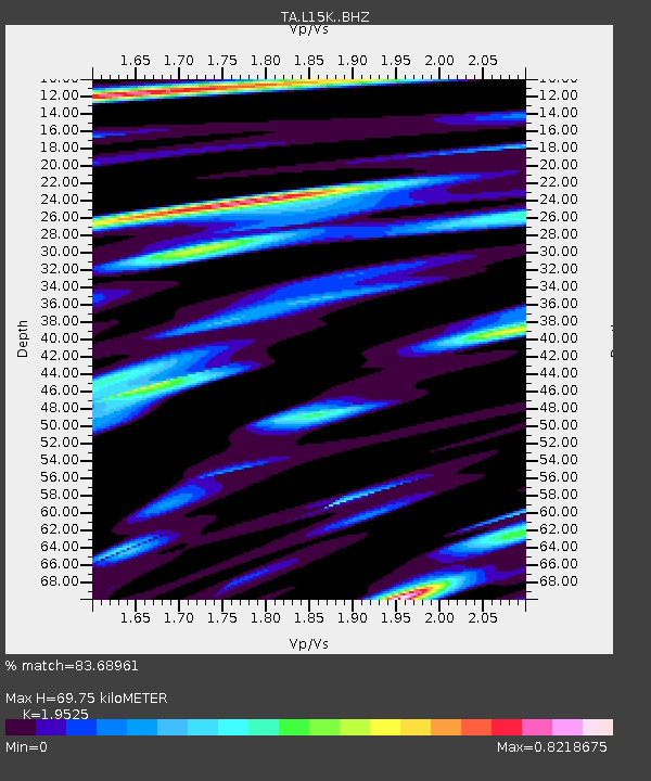
| Estimated Moho Depth: |
69.75 km |
| Estimated Crust Vp/Vs: |
1.95 |
| Assumed Crust Vp: |
6.182 km/s |
| Estimated Crust Vs: |
3.166 km/s |
| Estimated Crust Poisson's Ratio: |
0.32 |
|
| Radial Match: |
83.68961 % |
| Radial Bump: |
400 |
| Transverse Match: |
65.093094 % |
| Transverse Bump: |
400 |
| SOD ConfigId: |
13570011 |
| Insert Time: |
2019-05-02 22:22:38.655 +0000 |
| GWidth: |
2.5 |
| Max Bumps: |
400 |
| Tol: |
0.001 |
|
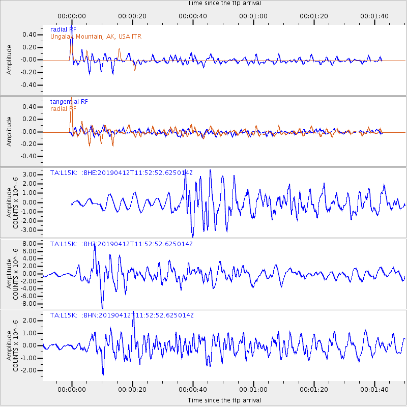
Signal To Noise
| Channel | StoN | STA | LTA |
| TA:L15K: :BHZ:20190412T11:52:52.625014Z | 3.3588336 | 1.1621594E-6 | 3.4600092E-7 |
| TA:L15K: :BHN:20190412T11:52:52.625014Z | 0.39822927 | 1.8808853E-7 | 4.723122E-7 |
| TA:L15K: :BHE:20190412T11:52:52.625014Z | 1.3335949 | 6.8567033E-7 | 5.141519E-7 |
| Arrivals |
| Ps | 11 SECOND |
| PpPs | 33 SECOND |
| PsPs/PpSs | 44 SECOND |


