You are here: Home > Network List > TA - USArray Transportable Network (new EarthScope stations) Stations List
> Station 125A Gardner Draw, Artesia, NM, USA > Earthquake Result Viewer
125A Gardner Draw, Artesia, NM, USA - Earthquake Result Viewer
| Earthquake location: |
Trinidad |
| Earthquake latitude/longitude: |
10.3/-60.4 |
| Earthquake time(UTC): |
2008/07/03 (185) 06:34:53 GMT |
| Earthquake Depth: |
34 km |
| Earthquake Magnitude: |
5.7 MB, 5.5 MS, 5.8 MW, 5.7 MW |
| Earthquake Catalog/Contributor: |
WHDF/NEIC |
|
| Network: |
TA USArray Transportable Network (new EarthScope stations) |
| Station: |
125A Gardner Draw, Artesia, NM, USA |
| Lat/Lon: |
32.66 N/104.66 W |
| Elevation: |
1212 m |
|
| Distance: |
46.4 deg |
| Az: |
305.613 deg |
| Baz: |
108.471 deg |
| Ray Param: |
0.07063248 |
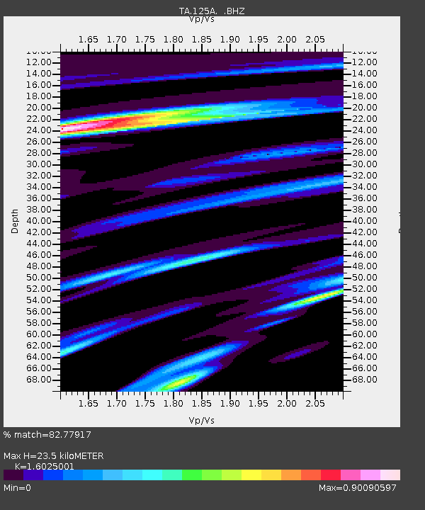
| Estimated Moho Depth: |
23.5 km |
| Estimated Crust Vp/Vs: |
1.60 |
| Assumed Crust Vp: |
6.232 km/s |
| Estimated Crust Vs: |
3.889 km/s |
| Estimated Crust Poisson's Ratio: |
0.18 |
|
| Radial Match: |
82.77917 % |
| Radial Bump: |
400 |
| Transverse Match: |
62.557278 % |
| Transverse Bump: |
400 |
| SOD ConfigId: |
2504 |
| Insert Time: |
2010-03-06 21:29:03.012 +0000 |
| GWidth: |
2.5 |
| Max Bumps: |
400 |
| Tol: |
0.001 |
|

Signal To Noise
| Channel | StoN | STA | LTA |
| TA:125A: :BHZ:20080703T06:42:45.973987Z | 2.9654887 | 2.342529E-7 | 7.899302E-8 |
| TA:125A: :BHN:20080703T06:42:45.973987Z | 0.8829004 | 4.082947E-8 | 4.6244704E-8 |
| TA:125A: :BHE:20080703T06:42:45.973987Z | 2.8860948 | 1.5115266E-7 | 5.237273E-8 |
| Arrivals |
| Ps | 2.4 SECOND |
| PpPs | 9.2 SECOND |
| PsPs/PpSs | 12 SECOND |


