You are here: Home > Network List > TA - USArray Transportable Network (new EarthScope stations) Stations List
> Station 125A Gardner Draw, Artesia, NM, USA > Earthquake Result Viewer
125A Gardner Draw, Artesia, NM, USA - Earthquake Result Viewer
*The percent match for this event was below the threshold and hence no stack was calculated.
| Earthquake location: |
Hokkaido, Japan Region |
| Earthquake latitude/longitude: |
41.5/142.0 |
| Earthquake time(UTC): |
2008/04/29 (120) 05:26:04 GMT |
| Earthquake Depth: |
47 km |
| Earthquake Magnitude: |
5.5 MB, 5.2 MS, 5.8 MW, 5.8 MW |
| Earthquake Catalog/Contributor: |
WHDF/NEIC |
|
| Network: |
TA USArray Transportable Network (new EarthScope stations) |
| Station: |
125A Gardner Draw, Artesia, NM, USA |
| Lat/Lon: |
32.66 N/104.66 W |
| Elevation: |
1212 m |
|
| Distance: |
84.1 deg |
| Az: |
51.154 deg |
| Baz: |
316.048 deg |
| Ray Param: |
$rayparam |
*The percent match for this event was below the threshold and hence was not used in the summary stack. |
|
| Radial Match: |
54.684666 % |
| Radial Bump: |
391 |
| Transverse Match: |
53.34223 % |
| Transverse Bump: |
375 |
| SOD ConfigId: |
2504 |
| Insert Time: |
2010-03-06 21:29:14.988 +0000 |
| GWidth: |
2.5 |
| Max Bumps: |
400 |
| Tol: |
0.001 |
|
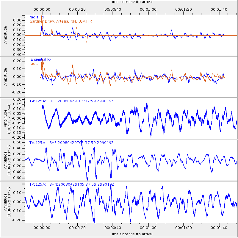
Signal To Noise
| Channel | StoN | STA | LTA |
| TA:125A: :BHZ:20080429T05:37:59.299019Z | 2.4311101 | 2.0255823E-7 | 8.331923E-8 |
| TA:125A: :BHN:20080429T05:37:59.299019Z | 1.4149662 | 5.074173E-8 | 3.5860737E-8 |
| TA:125A: :BHE:20080429T05:37:59.299019Z | 0.7151913 | 3.8758802E-8 | 5.4193613E-8 |
| Arrivals |
| Ps | |
| PpPs | |
| PsPs/PpSs | |


