You are here: Home > Network List > CI - Caltech Regional Seismic Network Stations List
> Station MPM Manuel Prospect Mine, California, USA > Earthquake Result Viewer
MPM Manuel Prospect Mine, California, USA - Earthquake Result Viewer
*The percent match for this event was below the threshold and hence no stack was calculated.
| Earthquake location: |
Samoa Islands Region |
| Earthquake latitude/longitude: |
-15.4/-172.7 |
| Earthquake time(UTC): |
2019/04/12 (102) 12:23:03 GMT |
| Earthquake Depth: |
10 km |
| Earthquake Magnitude: |
5.8 mb |
| Earthquake Catalog/Contributor: |
NEIC PDE/us |
|
| Network: |
CI Caltech Regional Seismic Network |
| Station: |
MPM Manuel Prospect Mine, California, USA |
| Lat/Lon: |
36.06 N/117.49 W |
| Elevation: |
185 m |
|
| Distance: |
73.1 deg |
| Az: |
44.085 deg |
| Baz: |
235.91 deg |
| Ray Param: |
$rayparam |
*The percent match for this event was below the threshold and hence was not used in the summary stack. |
|
| Radial Match: |
85.67893 % |
| Radial Bump: |
400 |
| Transverse Match: |
90.47655 % |
| Transverse Bump: |
334 |
| SOD ConfigId: |
13570011 |
| Insert Time: |
2019-05-02 22:28:42.487 +0000 |
| GWidth: |
2.5 |
| Max Bumps: |
400 |
| Tol: |
0.001 |
|
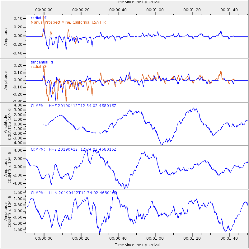
Signal To Noise
| Channel | StoN | STA | LTA |
| CI:MPM: :HHZ:20190412T12:34:02.468016Z | 2.1999204 | 3.1920606E-6 | 1.4509892E-6 |
| CI:MPM: :HHN:20190412T12:34:02.468016Z | 2.010659 | 7.618045E-7 | 3.7888296E-7 |
| CI:MPM: :HHE:20190412T12:34:02.468016Z | 1.7031233 | 1.8249873E-6 | 1.0715532E-6 |
| Arrivals |
| Ps | |
| PpPs | |
| PsPs/PpSs | |


