You are here: Home > Network List > TA - USArray Transportable Network (new EarthScope stations) Stations List
> Station 125A Gardner Draw, Artesia, NM, USA > Earthquake Result Viewer
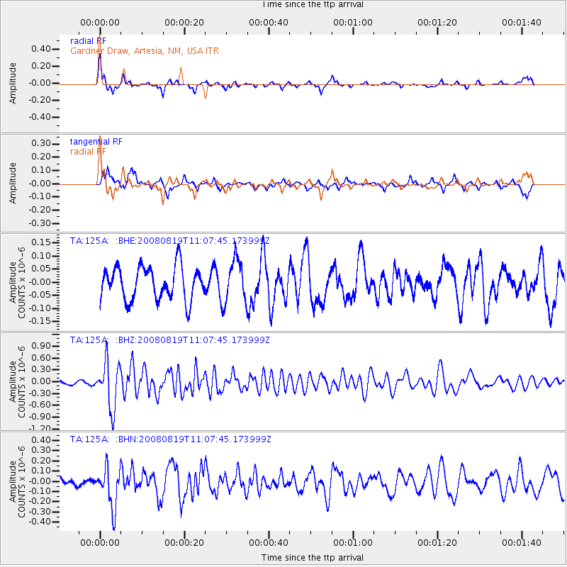
125A Gardner Draw, Artesia, NM, USA - Earthquake Result Viewer
*The percent match for this event was below the threshold and hence no stack was calculated.
| Earthquake location: |
Easter Island Region |
| Earthquake latitude/longitude: |
-28.5/-112.8 |
| Earthquake time(UTC): |
2008/08/19 (232) 10:58:00 GMT |
| Earthquake Depth: |
9.0 km |
| Earthquake Magnitude: |
5.5 MB, 5.3 MS, 5.7 MW, 5.7 MW |
| Earthquake Catalog/Contributor: |
WHDF/NEIC |
|
| Network: |
TA USArray Transportable Network (new EarthScope stations) |
| Station: |
125A Gardner Draw, Artesia, NM, USA |
| Lat/Lon: |
32.66 N/104.66 W |
| Elevation: |
1212 m |
|
| Distance: |
61.4 deg |
| Az: |
7.864 deg |
| Baz: |
188.205 deg |
| Ray Param: |
$rayparam |
*The percent match for this event was below the threshold and hence was not used in the summary stack. |
|
| Radial Match: |
73.26287 % |
| Radial Bump: |
280 |
| Transverse Match: |
62.032967 % |
| Transverse Bump: |
398 |
| SOD ConfigId: |
2504 |
| Insert Time: |
2010-03-06 21:29:36.683 +0000 |
| GWidth: |
2.5 |
| Max Bumps: |
400 |
| Tol: |
0.001 |
|
Signal To Noise
| Channel | StoN | STA | LTA |
| TA:125A: :BHZ:20080819T11:07:45.173999Z | 12.895456 | 5.9529197E-7 | 4.6162924E-8 |
| TA:125A: :BHN:20080819T11:07:45.173999Z | 4.415355 | 2.0032725E-7 | 4.5370587E-8 |
| TA:125A: :BHE:20080819T11:07:45.173999Z | 1.3202745 | 8.336189E-8 | 6.3139815E-8 |
| Arrivals |
| Ps | |
| PpPs | |
| PsPs/PpSs | |


