You are here: Home > Network List > TA - USArray Transportable Network (new EarthScope stations) Stations List
> Station 125A Gardner Draw, Artesia, NM, USA > Earthquake Result Viewer
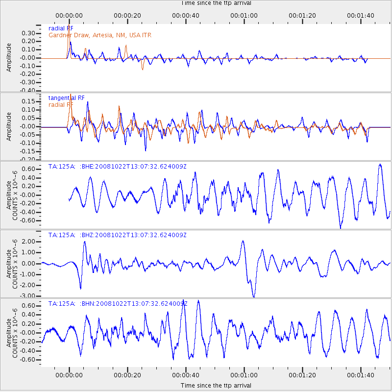
125A Gardner Draw, Artesia, NM, USA - Earthquake Result Viewer
*The percent match for this event was below the threshold and hence no stack was calculated.
| Earthquake location: |
Tonga Islands |
| Earthquake latitude/longitude: |
-18.4/-175.4 |
| Earthquake time(UTC): |
2008/10/22 (296) 12:55:57 GMT |
| Earthquake Depth: |
233 km |
| Earthquake Magnitude: |
5.9 MB, 6.4 MW, 6.3 MW |
| Earthquake Catalog/Contributor: |
WHDF/NEIC |
|
| Network: |
TA USArray Transportable Network (new EarthScope stations) |
| Station: |
125A Gardner Draw, Artesia, NM, USA |
| Lat/Lon: |
32.66 N/104.66 W |
| Elevation: |
1212 m |
|
| Distance: |
84.5 deg |
| Az: |
53.112 deg |
| Baz: |
244.186 deg |
| Ray Param: |
$rayparam |
*The percent match for this event was below the threshold and hence was not used in the summary stack. |
|
| Radial Match: |
69.310745 % |
| Radial Bump: |
319 |
| Transverse Match: |
45.795708 % |
| Transverse Bump: |
282 |
| SOD ConfigId: |
2556 |
| Insert Time: |
2010-03-06 21:29:41.904 +0000 |
| GWidth: |
2.5 |
| Max Bumps: |
400 |
| Tol: |
0.001 |
|
Signal To Noise
| Channel | StoN | STA | LTA |
| TA:125A: :BHZ:20081022T13:07:32.624009Z | 3.1029818 | 7.813403E-7 | 2.5180304E-7 |
| TA:125A: :BHN:20081022T13:07:32.624009Z | 1.3020893 | 2.1402421E-7 | 1.6436985E-7 |
| TA:125A: :BHE:20081022T13:07:32.624009Z | 1.4605184 | 2.6439355E-7 | 1.810272E-7 |
| Arrivals |
| Ps | |
| PpPs | |
| PsPs/PpSs | |


