You are here: Home > Network List > TA - USArray Transportable Network (new EarthScope stations) Stations List
> Station 125A Gardner Draw, Artesia, NM, USA > Earthquake Result Viewer
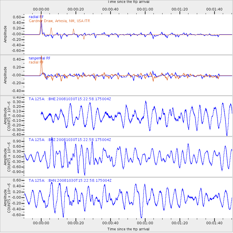
125A Gardner Draw, Artesia, NM, USA - Earthquake Result Viewer
*The percent match for this event was below the threshold and hence no stack was calculated.
| Earthquake location: |
Central East Pacific Rise |
| Earthquake latitude/longitude: |
-9.0/-108.2 |
| Earthquake time(UTC): |
2008/10/30 (304) 15:15:41 GMT |
| Earthquake Depth: |
10 km |
| Earthquake Magnitude: |
5.5 MB, 5.8 MS, 6.0 MW, 6.0 MW |
| Earthquake Catalog/Contributor: |
WHDF/NEIC |
|
| Network: |
TA USArray Transportable Network (new EarthScope stations) |
| Station: |
125A Gardner Draw, Artesia, NM, USA |
| Lat/Lon: |
32.66 N/104.66 W |
| Elevation: |
1212 m |
|
| Distance: |
41.6 deg |
| Az: |
4.563 deg |
| Baz: |
185.345 deg |
| Ray Param: |
$rayparam |
*The percent match for this event was below the threshold and hence was not used in the summary stack. |
|
| Radial Match: |
61.73319 % |
| Radial Bump: |
319 |
| Transverse Match: |
53.689705 % |
| Transverse Bump: |
338 |
| SOD ConfigId: |
2560 |
| Insert Time: |
2010-03-06 21:29:54.761 +0000 |
| GWidth: |
2.5 |
| Max Bumps: |
400 |
| Tol: |
0.001 |
|
Signal To Noise
| Channel | StoN | STA | LTA |
| TA:125A: :BHZ:20081030T15:22:58.175004Z | 1.9032464 | 3.4108209E-7 | 1.7921067E-7 |
| TA:125A: :BHN:20081030T15:22:58.175004Z | 1.3888376 | 1.8918217E-7 | 1.362162E-7 |
| TA:125A: :BHE:20081030T15:22:58.175004Z | 1.3240764 | 1.4698634E-7 | 1.1101046E-7 |
| Arrivals |
| Ps | |
| PpPs | |
| PsPs/PpSs | |


