You are here: Home > Network List > TA - USArray Transportable Network (new EarthScope stations) Stations List
> Station 125A Gardner Draw, Artesia, NM, USA > Earthquake Result Viewer
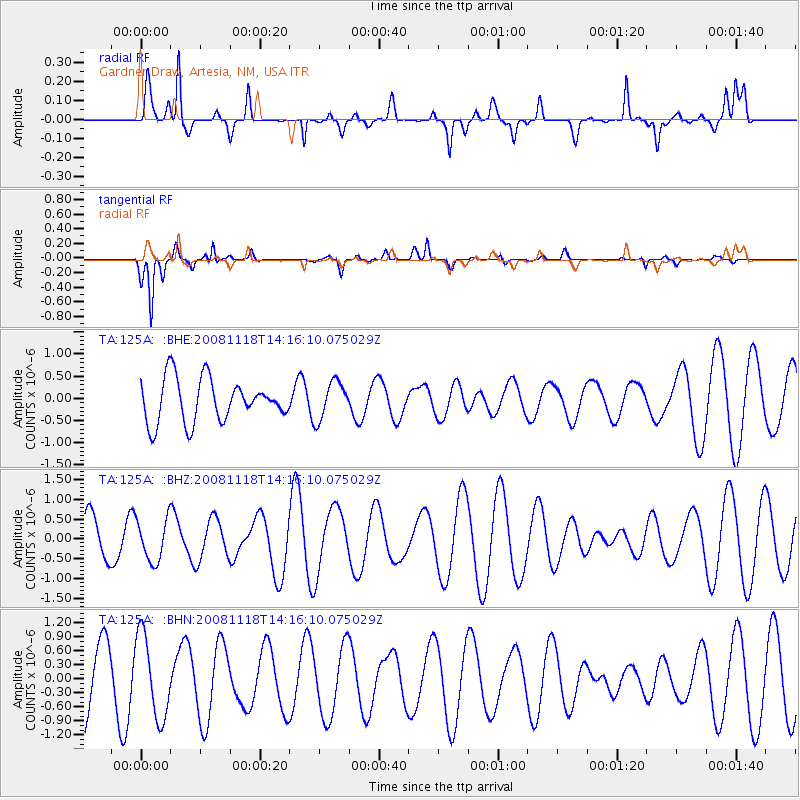
125A Gardner Draw, Artesia, NM, USA - Earthquake Result Viewer
*The percent match for this event was below the threshold and hence no stack was calculated.
| Earthquake location: |
Vanuatu Islands |
| Earthquake latitude/longitude: |
-18.9/169.5 |
| Earthquake time(UTC): |
2008/11/18 (323) 14:03:15 GMT |
| Earthquake Depth: |
35 km |
| Earthquake Magnitude: |
5.5 MB, 5.3 MS, 5.5 MW |
| Earthquake Catalog/Contributor: |
WHDF/NEIC |
|
| Network: |
TA USArray Transportable Network (new EarthScope stations) |
| Station: |
125A Gardner Draw, Artesia, NM, USA |
| Lat/Lon: |
32.66 N/104.66 W |
| Elevation: |
1212 m |
|
| Distance: |
96.6 deg |
| Az: |
57.886 deg |
| Baz: |
251.922 deg |
| Ray Param: |
$rayparam |
*The percent match for this event was below the threshold and hence was not used in the summary stack. |
|
| Radial Match: |
53.768673 % |
| Radial Bump: |
350 |
| Transverse Match: |
83.64418 % |
| Transverse Bump: |
245 |
| SOD ConfigId: |
2658 |
| Insert Time: |
2010-03-06 21:29:56.708 +0000 |
| GWidth: |
2.5 |
| Max Bumps: |
400 |
| Tol: |
0.001 |
|
Signal To Noise
| Channel | StoN | STA | LTA |
| TA:125A: :BHZ:20081118T14:16:10.075029Z | 0.81256956 | 5.2843455E-7 | 6.5032526E-7 |
| TA:125A: :BHN:20081118T14:16:10.075029Z | 1.761149 | 8.8908786E-7 | 5.0483396E-7 |
| TA:125A: :BHE:20081118T14:16:10.075029Z | 0.87786454 | 4.219845E-7 | 4.806943E-7 |
| Arrivals |
| Ps | |
| PpPs | |
| PsPs/PpSs | |


