You are here: Home > Network List > TA - USArray Transportable Network (new EarthScope stations) Stations List
> Station J26L Joseph Creek, AK, USA > Earthquake Result Viewer
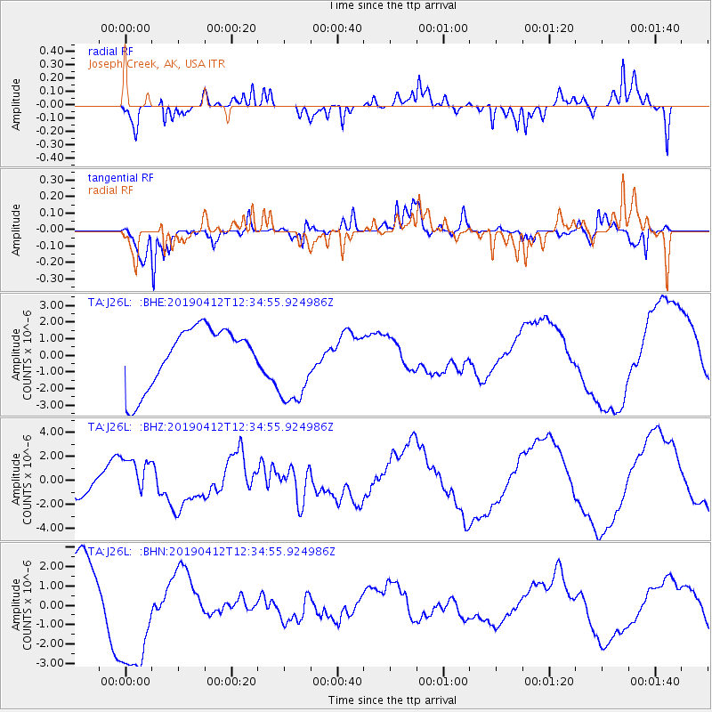
J26L Joseph Creek, AK, USA - Earthquake Result Viewer
*The percent match for this event was below the threshold and hence no stack was calculated.
| Earthquake location: |
Samoa Islands Region |
| Earthquake latitude/longitude: |
-15.4/-172.7 |
| Earthquake time(UTC): |
2019/04/12 (102) 12:23:03 GMT |
| Earthquake Depth: |
10 km |
| Earthquake Magnitude: |
5.8 mb |
| Earthquake Catalog/Contributor: |
NEIC PDE/us |
|
| Network: |
TA USArray Transportable Network (new EarthScope stations) |
| Station: |
J26L Joseph Creek, AK, USA |
| Lat/Lon: |
64.50 N/143.56 W |
| Elevation: |
1144 m |
|
| Distance: |
82.7 deg |
| Az: |
12.273 deg |
| Baz: |
208.273 deg |
| Ray Param: |
$rayparam |
*The percent match for this event was below the threshold and hence was not used in the summary stack. |
|
| Radial Match: |
81.69019 % |
| Radial Bump: |
400 |
| Transverse Match: |
90.44492 % |
| Transverse Bump: |
381 |
| SOD ConfigId: |
13570011 |
| Insert Time: |
2019-05-02 22:32:23.589 +0000 |
| GWidth: |
2.5 |
| Max Bumps: |
400 |
| Tol: |
0.001 |
|
Signal To Noise
| Channel | StoN | STA | LTA |
| TA:J26L: :BHZ:20190412T12:34:55.924986Z | 2.4419885 | 1.7733156E-6 | 7.2617695E-7 |
| TA:J26L: :BHN:20190412T12:34:55.924986Z | 1.5455444 | 3.0825286E-6 | 1.9944614E-6 |
| TA:J26L: :BHE:20190412T12:34:55.924986Z | 1.4514287 | 2.559187E-6 | 1.7632192E-6 |
| Arrivals |
| Ps | |
| PpPs | |
| PsPs/PpSs | |


