You are here: Home > Network List > TA - USArray Transportable Network (new EarthScope stations) Stations List
> Station T33K Petersburg, AK, USA > Earthquake Result Viewer
T33K Petersburg, AK, USA - Earthquake Result Viewer

| Earthquake location: |
Samoa Islands Region |
| Earthquake latitude/longitude: |
-15.4/-172.7 |
| Earthquake time(UTC): |
2019/04/12 (102) 12:23:03 GMT |
| Earthquake Depth: |
10 km |
| Earthquake Magnitude: |
5.8 mb |
| Earthquake Catalog/Contributor: |
NEIC PDE/us |
|
| Network: |
TA USArray Transportable Network (new EarthScope stations) |
| Station: |
T33K Petersburg, AK, USA |
| Lat/Lon: |
56.81 N/132.95 W |
| Elevation: |
22 m |
|
| Distance: |
79.2 deg |
| Az: |
20.983 deg |
| Baz: |
218.907 deg |
| Ray Param: |
0.049121704 |
| Estimated Moho Depth: |
30.5 km |
| Estimated Crust Vp/Vs: |
2.08 |
| Assumed Crust Vp: |
6.597 km/s |
| Estimated Crust Vs: |
3.18 km/s |
| Estimated Crust Poisson's Ratio: |
0.35 |
|
| Radial Match: |
87.17777 % |
| Radial Bump: |
400 |
| Transverse Match: |
87.464554 % |
| Transverse Bump: |
400 |
| SOD ConfigId: |
13570011 |
| Insert Time: |
2019-05-02 22:32:41.340 +0000 |
| GWidth: |
2.5 |
| Max Bumps: |
400 |
| Tol: |
0.001 |
|
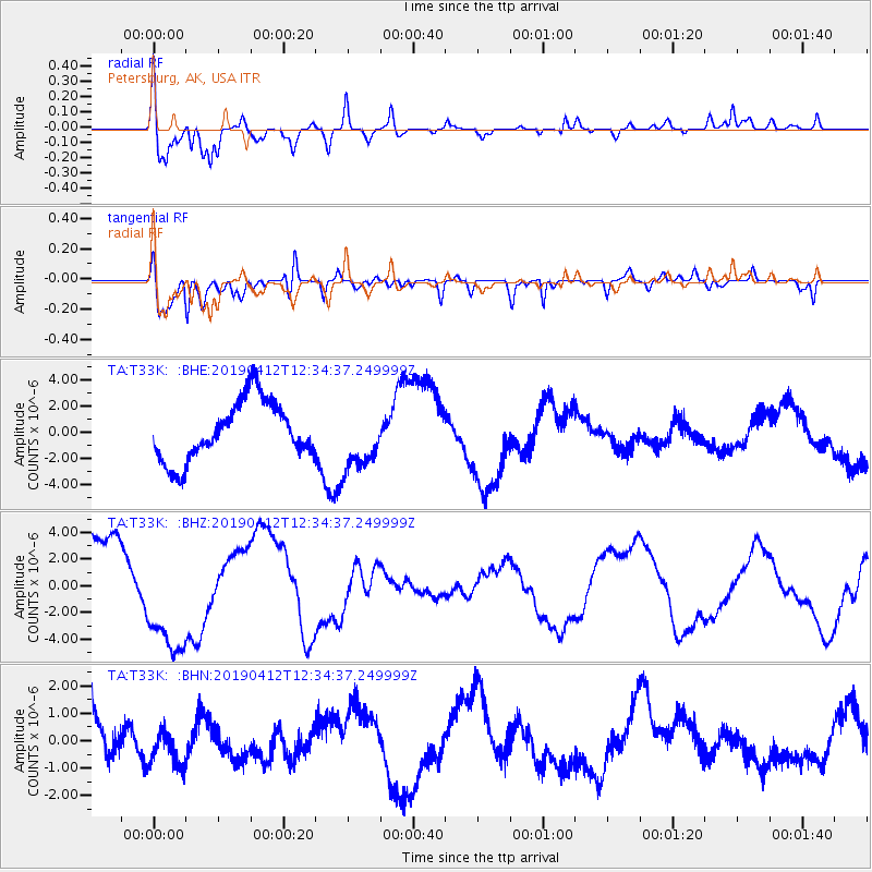
Signal To Noise
| Channel | StoN | STA | LTA |
| TA:T33K: :BHZ:20190412T12:34:37.249999Z | 1.5577693 | 4.4574767E-6 | 2.8614486E-6 |
| TA:T33K: :BHN:20190412T12:34:37.249999Z | 0.62169313 | 7.8445964E-7 | 1.2618117E-6 |
| TA:T33K: :BHE:20190412T12:34:37.249999Z | 1.0546402 | 2.3565892E-6 | 2.2344957E-6 |
| Arrivals |
| Ps | 5.1 SECOND |
| PpPs | 14 SECOND |
| PsPs/PpSs | 19 SECOND |


