You are here: Home > Network List > IW - Intermountain West Stations List
> Station MOOW Moose Ponds, Wyoming, USA > Earthquake Result Viewer
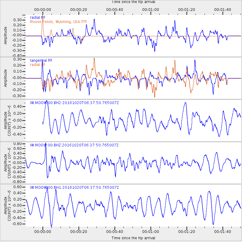
MOOW Moose Ponds, Wyoming, USA - Earthquake Result Viewer
*The percent match for this event was below the threshold and hence no stack was calculated.
| Earthquake location: |
Volcano Islands, Japan Region |
| Earthquake latitude/longitude: |
22.3/143.8 |
| Earthquake time(UTC): |
2016/10/20 (294) 06:25:56 GMT |
| Earthquake Depth: |
108 km |
| Earthquake Magnitude: |
5.7 MB |
| Earthquake Catalog/Contributor: |
NEIC PDE/NEIC COMCAT |
|
| Network: |
IW Intermountain West |
| Station: |
MOOW Moose Ponds, Wyoming, USA |
| Lat/Lon: |
43.75 N/110.74 W |
| Elevation: |
2128 m |
|
| Distance: |
85.4 deg |
| Az: |
44.476 deg |
| Baz: |
296.43 deg |
| Ray Param: |
$rayparam |
*The percent match for this event was below the threshold and hence was not used in the summary stack. |
|
| Radial Match: |
51.9579 % |
| Radial Bump: |
400 |
| Transverse Match: |
49.72313 % |
| Transverse Bump: |
340 |
| SOD ConfigId: |
1815711 |
| Insert Time: |
2016-11-03 06:28:15.974 +0000 |
| GWidth: |
2.5 |
| Max Bumps: |
400 |
| Tol: |
0.001 |
|
Signal To Noise
| Channel | StoN | STA | LTA |
| IW:MOOW:00:BHZ:20161020T06:37:50.765007Z | 1.4684558 | 3.5059662E-7 | 2.387519E-7 |
| IW:MOOW:00:BH1:20161020T06:37:50.765007Z | 1.9739473 | 3.818013E-7 | 1.9342022E-7 |
| IW:MOOW:00:BH2:20161020T06:37:50.765007Z | 0.28153104 | 6.4733705E-8 | 2.2993453E-7 |
| Arrivals |
| Ps | |
| PpPs | |
| PsPs/PpSs | |


