You are here: Home > Network List > TS - TERRAscope (Southern California Seismic Network) Stations List
> Station DGR Domenigoni Valley Reservior, California, USA > Earthquake Result Viewer
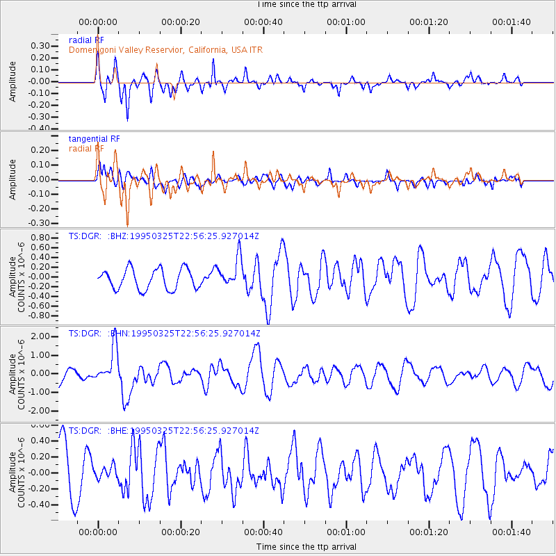
DGR Domenigoni Valley Reservior, California, USA - Earthquake Result Viewer
*The percent match for this event was below the threshold and hence no stack was calculated.
| Earthquake location: |
Santa Cruz Islands |
| Earthquake latitude/longitude: |
-11.1/166.1 |
| Earthquake time(UTC): |
1995/03/25 (084) 22:44:28 GMT |
| Earthquake Depth: |
77 km |
| Earthquake Magnitude: |
5.9 MB, 5.9 UNKNOWN, 6.3 MW |
| Earthquake Catalog/Contributor: |
WHDF/NEIC |
|
| Network: |
TS TERRAscope (Southern California Seismic Network) |
| Station: |
DGR Domenigoni Valley Reservior, California, USA |
| Lat/Lon: |
33.65 N/117.01 W |
| Elevation: |
700 m |
|
| Distance: |
85.4 deg |
| Az: |
54.592 deg |
| Baz: |
253.58 deg |
| Ray Param: |
$rayparam |
*The percent match for this event was below the threshold and hence was not used in the summary stack. |
|
| Radial Match: |
79.25572 % |
| Radial Bump: |
395 |
| Transverse Match: |
31.992735 % |
| Transverse Bump: |
400 |
| SOD ConfigId: |
4480 |
| Insert Time: |
2010-02-26 14:10:33.173 +0000 |
| GWidth: |
2.5 |
| Max Bumps: |
400 |
| Tol: |
0.001 |
|
Signal To Noise
| Channel | StoN | STA | LTA |
| TS:DGR: :BHN:19950325T22:56:25.927014Z | 2.351611 | 1.0168195E-6 | 4.3239277E-7 |
| TS:DGR: :BHE:19950325T22:56:25.927014Z | 0.20138092 | 7.560204E-8 | 3.7541807E-7 |
| TS:DGR: :BHZ:19950325T22:56:25.927014Z | 1.5420961 | 3.1734822E-7 | 2.0579016E-7 |
| Arrivals |
| Ps | |
| PpPs | |
| PsPs/PpSs | |


