You are here: Home > Network List > TS - TERRAscope (Southern California Seismic Network) Stations List
> Station DGR Domenigoni Valley Reservior, California, USA > Earthquake Result Viewer
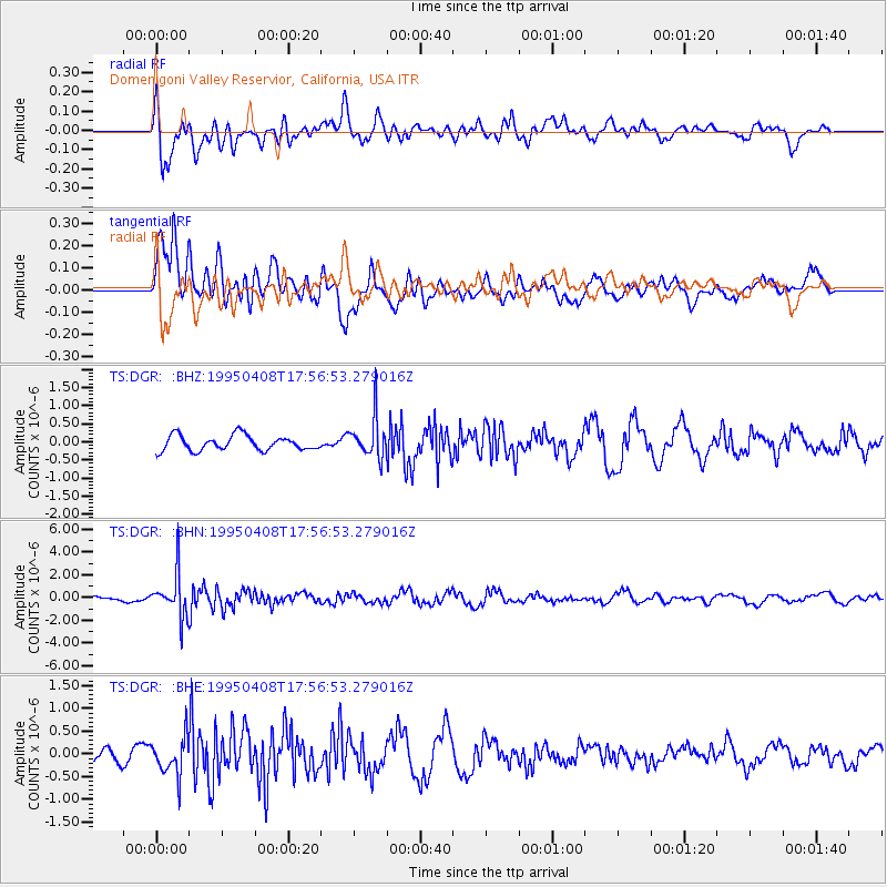
DGR Domenigoni Valley Reservior, California, USA - Earthquake Result Viewer
*The percent match for this event was below the threshold and hence no stack was calculated.
| Earthquake location: |
Mariana Islands Region |
| Earthquake latitude/longitude: |
21.8/142.6 |
| Earthquake time(UTC): |
1995/04/08 (098) 17:45:18 GMT |
| Earthquake Depth: |
319 km |
| Earthquake Magnitude: |
6.3 MB |
| Earthquake Catalog/Contributor: |
WHDF/NEIC |
|
| Network: |
TS TERRAscope (Southern California Seismic Network) |
| Station: |
DGR Domenigoni Valley Reservior, California, USA |
| Lat/Lon: |
33.65 N/117.01 W |
| Elevation: |
700 m |
|
| Distance: |
86.3 deg |
| Az: |
55.311 deg |
| Baz: |
293.643 deg |
| Ray Param: |
$rayparam |
*The percent match for this event was below the threshold and hence was not used in the summary stack. |
|
| Radial Match: |
70.07009 % |
| Radial Bump: |
400 |
| Transverse Match: |
82.82302 % |
| Transverse Bump: |
400 |
| SOD ConfigId: |
4480 |
| Insert Time: |
2010-02-26 14:10:35.556 +0000 |
| GWidth: |
2.5 |
| Max Bumps: |
400 |
| Tol: |
0.001 |
|
Signal To Noise
| Channel | StoN | STA | LTA |
| TS:DGR: :BHN:19950408T17:56:53.279016Z | 5.8606706 | 1.9165998E-6 | 3.270274E-7 |
| TS:DGR: :BHE:19950408T17:56:53.279016Z | 2.3151839 | 4.127639E-7 | 1.7828557E-7 |
| TS:DGR: :BHZ:19950408T17:56:53.279016Z | 2.6716971 | 5.5230475E-7 | 2.067243E-7 |
| Arrivals |
| Ps | |
| PpPs | |
| PsPs/PpSs | |


