You are here: Home > Network List > TA - USArray Transportable Network (new EarthScope stations) Stations List
> Station 125A Gardner Draw, Artesia, NM, USA > Earthquake Result Viewer
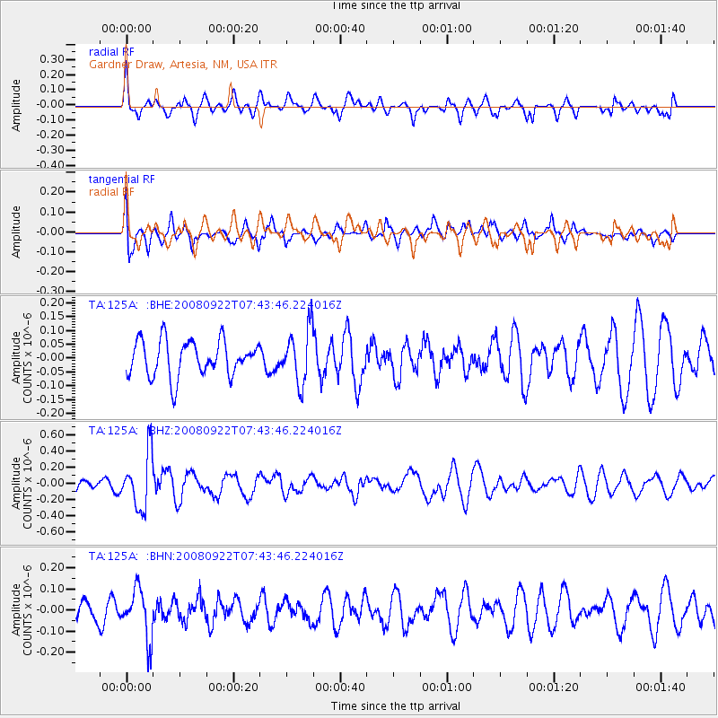
125A Gardner Draw, Artesia, NM, USA - Earthquake Result Viewer
*The percent match for this event was below the threshold and hence no stack was calculated.
| Earthquake location: |
Hokkaido, Japan Region |
| Earthquake latitude/longitude: |
41.6/140.4 |
| Earthquake time(UTC): |
2008/09/22 (266) 07:31:59 GMT |
| Earthquake Depth: |
149 km |
| Earthquake Magnitude: |
5.7 MW, 5.3 MB, 5.6 MW |
| Earthquake Catalog/Contributor: |
WHDF/NEIC |
|
| Network: |
TA USArray Transportable Network (new EarthScope stations) |
| Station: |
125A Gardner Draw, Artesia, NM, USA |
| Lat/Lon: |
32.66 N/104.66 W |
| Elevation: |
1212 m |
|
| Distance: |
84.9 deg |
| Az: |
50.193 deg |
| Baz: |
316.902 deg |
| Ray Param: |
$rayparam |
*The percent match for this event was below the threshold and hence was not used in the summary stack. |
|
| Radial Match: |
47.14601 % |
| Radial Bump: |
370 |
| Transverse Match: |
57.047474 % |
| Transverse Bump: |
400 |
| SOD ConfigId: |
2560 |
| Insert Time: |
2010-03-06 21:30:46.055 +0000 |
| GWidth: |
2.5 |
| Max Bumps: |
400 |
| Tol: |
0.001 |
|
Signal To Noise
| Channel | StoN | STA | LTA |
| TA:125A: :BHZ:20080922T07:43:46.224016Z | 2.8905878 | 3.4395006E-7 | 1.1898966E-7 |
| TA:125A: :BHN:20080922T07:43:46.224016Z | 2.3812523 | 1.1897348E-7 | 4.996257E-8 |
| TA:125A: :BHE:20080922T07:43:46.224016Z | 1.55486 | 1.0029645E-7 | 6.450513E-8 |
| Arrivals |
| Ps | |
| PpPs | |
| PsPs/PpSs | |


