You are here: Home > Network List > TA - USArray Transportable Network (new EarthScope stations) Stations List
> Station D22A Cohagen, MT, USA > Earthquake Result Viewer
D22A Cohagen, MT, USA - Earthquake Result Viewer
| Earthquake location: |
Honduras |
| Earthquake latitude/longitude: |
15.8/-86.9 |
| Earthquake time(UTC): |
2009/06/08 (159) 05:13:14 GMT |
| Earthquake Depth: |
10 km |
| Earthquake Magnitude: |
5.5 MB, 4.9 MS, 5.4 MW, 5.4 MW |
| Earthquake Catalog/Contributor: |
WHDF/NEIC |
|
| Network: |
TA USArray Transportable Network (new EarthScope stations) |
| Station: |
D22A Cohagen, MT, USA |
| Lat/Lon: |
47.15 N/106.18 W |
| Elevation: |
791 m |
|
| Distance: |
35.1 deg |
| Az: |
336.905 deg |
| Baz: |
146.408 deg |
| Ray Param: |
0.077380344 |
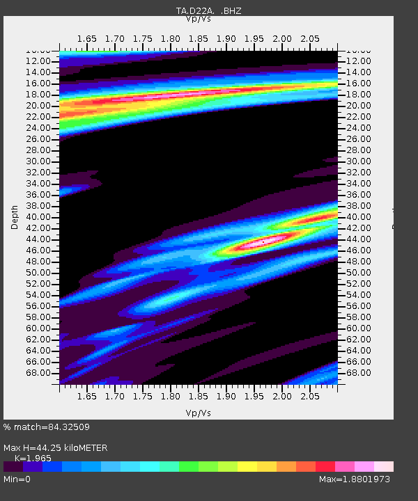
| Estimated Moho Depth: |
44.25 km |
| Estimated Crust Vp/Vs: |
1.97 |
| Assumed Crust Vp: |
6.438 km/s |
| Estimated Crust Vs: |
3.276 km/s |
| Estimated Crust Poisson's Ratio: |
0.33 |
|
| Radial Match: |
84.32509 % |
| Radial Bump: |
299 |
| Transverse Match: |
63.7707 % |
| Transverse Bump: |
378 |
| SOD ConfigId: |
2648 |
| Insert Time: |
2010-03-06 21:30:56.328 +0000 |
| GWidth: |
2.5 |
| Max Bumps: |
400 |
| Tol: |
0.001 |
|
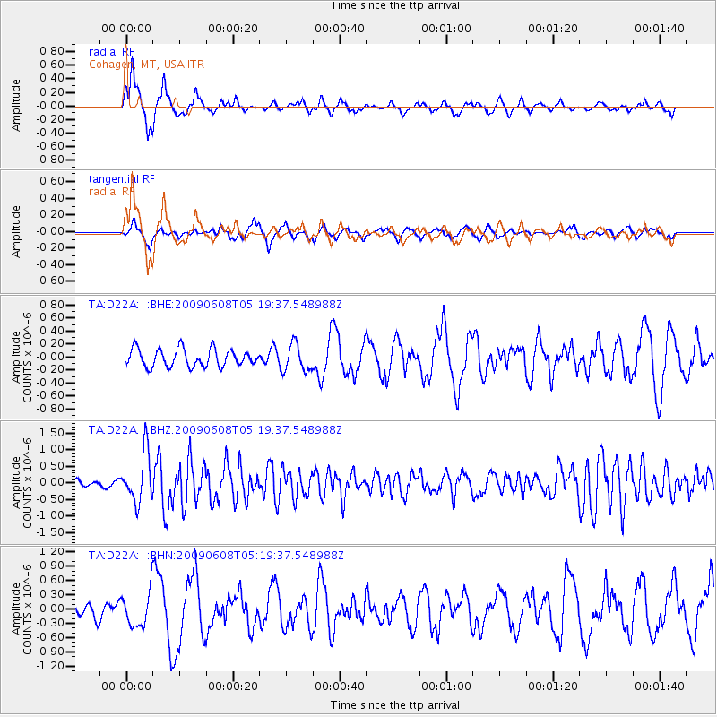
Signal To Noise
| Channel | StoN | STA | LTA |
| TA:D22A: :BHZ:20090608T05:19:37.548988Z | 4.4963994 | 7.535806E-7 | 1.6759647E-7 |
| TA:D22A: :BHN:20090608T05:19:37.548988Z | 1.698385 | 3.6129703E-7 | 2.1272974E-7 |
| TA:D22A: :BHE:20090608T05:19:37.548988Z | 1.586076 | 2.1091724E-7 | 1.3298055E-7 |
| Arrivals |
| Ps | 7.1 SECOND |
| PpPs | 19 SECOND |
| PsPs/PpSs | 26 SECOND |


