You are here: Home > Network List > TA - USArray Transportable Network (new EarthScope stations) Stations List
> Station D22A Cohagen, MT, USA > Earthquake Result Viewer
D22A Cohagen, MT, USA - Earthquake Result Viewer
| Earthquake location: |
Tonga Islands Region |
| Earthquake latitude/longitude: |
-23.0/-174.7 |
| Earthquake time(UTC): |
2009/03/19 (078) 18:17:40 GMT |
| Earthquake Depth: |
34 km |
| Earthquake Magnitude: |
7.0 MB, 7.6 MS, 7.6 MW, 7.6 MW |
| Earthquake Catalog/Contributor: |
WHDF/NEIC |
|
| Network: |
TA USArray Transportable Network (new EarthScope stations) |
| Station: |
D22A Cohagen, MT, USA |
| Lat/Lon: |
47.15 N/106.18 W |
| Elevation: |
791 m |
|
| Distance: |
93.1 deg |
| Az: |
39.485 deg |
| Baz: |
239.111 deg |
| Ray Param: |
0.041318752 |
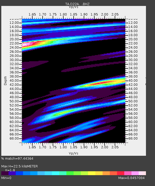
| Estimated Moho Depth: |
22.5 km |
| Estimated Crust Vp/Vs: |
1.60 |
| Assumed Crust Vp: |
6.438 km/s |
| Estimated Crust Vs: |
4.023 km/s |
| Estimated Crust Poisson's Ratio: |
0.18 |
|
| Radial Match: |
97.44364 % |
| Radial Bump: |
400 |
| Transverse Match: |
94.80447 % |
| Transverse Bump: |
400 |
| SOD ConfigId: |
2658 |
| Insert Time: |
2010-03-06 21:30:59.806 +0000 |
| GWidth: |
2.5 |
| Max Bumps: |
400 |
| Tol: |
0.001 |
|
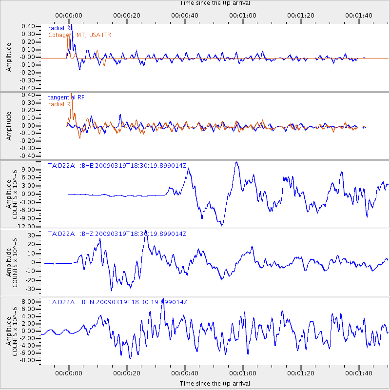
Signal To Noise
| Channel | StoN | STA | LTA |
| TA:D22A: :BHZ:20090319T18:30:19.899014Z | 16.818916 | 3.9904107E-6 | 2.3725731E-7 |
| TA:D22A: :BHN:20090319T18:30:19.899014Z | 1.6921269 | 5.742348E-7 | 3.3935683E-7 |
| TA:D22A: :BHE:20090319T18:30:19.899014Z | 3.422752 | 8.2062706E-7 | 2.397565E-7 |
| Arrivals |
| Ps | 2.1 SECOND |
| PpPs | 8.9 SECOND |
| PsPs/PpSs | 11 SECOND |


