You are here: Home > Network List > TA - USArray Transportable Network (new EarthScope stations) Stations List
> Station D22A Cohagen, MT, USA > Earthquake Result Viewer
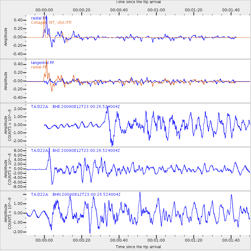
D22A Cohagen, MT, USA - Earthquake Result Viewer
*The percent match for this event was below the threshold and hence no stack was calculated.
| Earthquake location: |
Southeast Of Honshu, Japan |
| Earthquake latitude/longitude: |
32.8/140.4 |
| Earthquake time(UTC): |
2009/08/12 (224) 22:48:51 GMT |
| Earthquake Depth: |
53 km |
| Earthquake Magnitude: |
6.2 MB, 6.6 MW, 6.6 MW |
| Earthquake Catalog/Contributor: |
WHDF/NEIC |
|
| Network: |
TA USArray Transportable Network (new EarthScope stations) |
| Station: |
D22A Cohagen, MT, USA |
| Lat/Lon: |
47.15 N/106.18 W |
| Elevation: |
791 m |
|
| Distance: |
80.5 deg |
| Az: |
39.425 deg |
| Baz: |
308.421 deg |
| Ray Param: |
$rayparam |
*The percent match for this event was below the threshold and hence was not used in the summary stack. |
|
| Radial Match: |
93.32087 % |
| Radial Bump: |
264 |
| Transverse Match: |
78.30968 % |
| Transverse Bump: |
397 |
| SOD ConfigId: |
2622 |
| Insert Time: |
2010-03-06 21:31:15.725 +0000 |
| GWidth: |
2.5 |
| Max Bumps: |
400 |
| Tol: |
0.001 |
|
Signal To Noise
| Channel | StoN | STA | LTA |
| TA:D22A: :BHZ:20090812T23:00:26.524004Z | 38.733063 | 3.825149E-6 | 9.875669E-8 |
| TA:D22A: :BHN:20090812T23:00:26.524004Z | 3.090767 | 7.304165E-7 | 2.363221E-7 |
| TA:D22A: :BHE:20090812T23:00:26.524004Z | 5.113806 | 1.0137732E-6 | 1.9824242E-7 |
| Arrivals |
| Ps | |
| PpPs | |
| PsPs/PpSs | |


