You are here: Home > Network List > TA - USArray Transportable Network (new EarthScope stations) Stations List
> Station D22A Cohagen, MT, USA > Earthquake Result Viewer
D22A Cohagen, MT, USA - Earthquake Result Viewer
*The percent match for this event was below the threshold and hence no stack was calculated.
| Earthquake location: |
North Of Honduras |
| Earthquake latitude/longitude: |
16.7/-86.2 |
| Earthquake time(UTC): |
2009/05/28 (148) 08:24:45 GMT |
| Earthquake Depth: |
10 km |
| Earthquake Magnitude: |
6.7 MB, 7.2 MS, 7.3 MW, 7.3 MW |
| Earthquake Catalog/Contributor: |
WHDF/NEIC |
|
| Network: |
TA USArray Transportable Network (new EarthScope stations) |
| Station: |
D22A Cohagen, MT, USA |
| Lat/Lon: |
47.15 N/106.18 W |
| Elevation: |
791 m |
|
| Distance: |
34.5 deg |
| Az: |
335.75 deg |
| Baz: |
144.786 deg |
| Ray Param: |
$rayparam |
*The percent match for this event was below the threshold and hence was not used in the summary stack. |
|
| Radial Match: |
98.73876 % |
| Radial Bump: |
195 |
| Transverse Match: |
91.84157 % |
| Transverse Bump: |
400 |
| SOD ConfigId: |
2648 |
| Insert Time: |
2010-03-06 21:31:45.609 +0000 |
| GWidth: |
2.5 |
| Max Bumps: |
400 |
| Tol: |
0.001 |
|
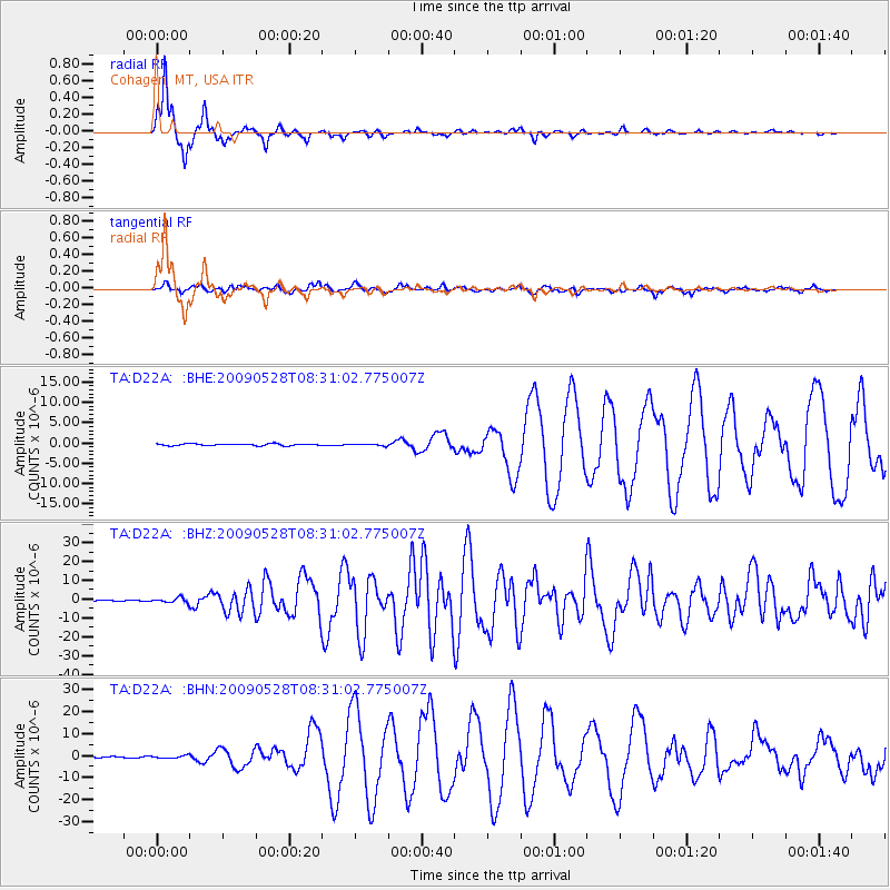
Signal To Noise
| Channel | StoN | STA | LTA |
| TA:D22A: :BHZ:20090528T08:31:02.775007Z | 8.382728 | 1.2619181E-6 | 1.5053787E-7 |
| TA:D22A: :BHN:20090528T08:31:02.775007Z | 1.93078 | 5.7319033E-7 | 2.9686984E-7 |
| TA:D22A: :BHE:20090528T08:31:02.775007Z | 0.88782585 | 1.9530113E-7 | 2.1997683E-7 |
| Arrivals |
| Ps | |
| PpPs | |
| PsPs/PpSs | |


