You are here: Home > Network List > TA - USArray Transportable Network (new EarthScope stations) Stations List
> Station D22A Cohagen, MT, USA > Earthquake Result Viewer
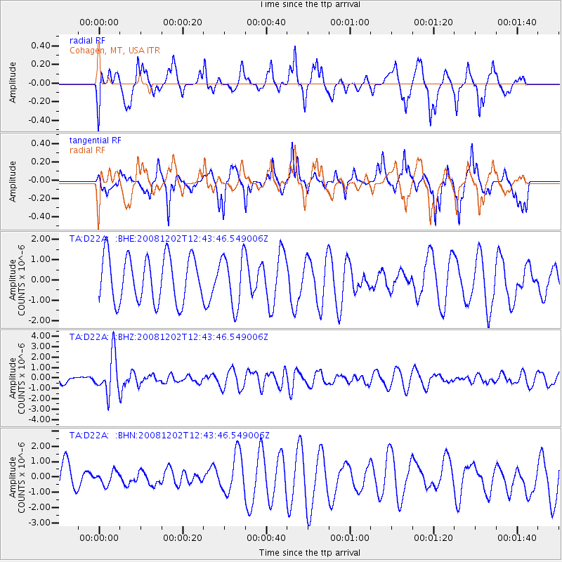
D22A Cohagen, MT, USA - Earthquake Result Viewer
*The percent match for this event was below the threshold and hence no stack was calculated.
| Earthquake location: |
Mariana Islands |
| Earthquake latitude/longitude: |
19.1/145.8 |
| Earthquake time(UTC): |
2008/12/02 (337) 12:31:43 GMT |
| Earthquake Depth: |
137 km |
| Earthquake Magnitude: |
5.9 MB, 5.9 MW, 5.9 MW |
| Earthquake Catalog/Contributor: |
WHDF/NEIC |
|
| Network: |
TA USArray Transportable Network (new EarthScope stations) |
| Station: |
D22A Cohagen, MT, USA |
| Lat/Lon: |
47.15 N/106.18 W |
| Elevation: |
791 m |
|
| Distance: |
87.8 deg |
| Az: |
40.491 deg |
| Baz: |
295.897 deg |
| Ray Param: |
$rayparam |
*The percent match for this event was below the threshold and hence was not used in the summary stack. |
|
| Radial Match: |
48.823097 % |
| Radial Bump: |
309 |
| Transverse Match: |
55.759266 % |
| Transverse Bump: |
324 |
| SOD ConfigId: |
2658 |
| Insert Time: |
2010-03-06 21:31:49.308 +0000 |
| GWidth: |
2.5 |
| Max Bumps: |
400 |
| Tol: |
0.001 |
|
Signal To Noise
| Channel | StoN | STA | LTA |
| TA:D22A: :BHZ:20081202T12:43:46.549006Z | 5.0055857 | 1.9219767E-6 | 3.839664E-7 |
| TA:D22A: :BHN:20081202T12:43:46.549006Z | 0.35302377 | 4.3271808E-7 | 1.2257477E-6 |
| TA:D22A: :BHE:20081202T12:43:46.549006Z | 1.1553205 | 1.2990935E-6 | 1.1244442E-6 |
| Arrivals |
| Ps | |
| PpPs | |
| PsPs/PpSs | |


