You are here: Home > Network List > TA - USArray Transportable Network (new EarthScope stations) Stations List
> Station D22A Cohagen, MT, USA > Earthquake Result Viewer
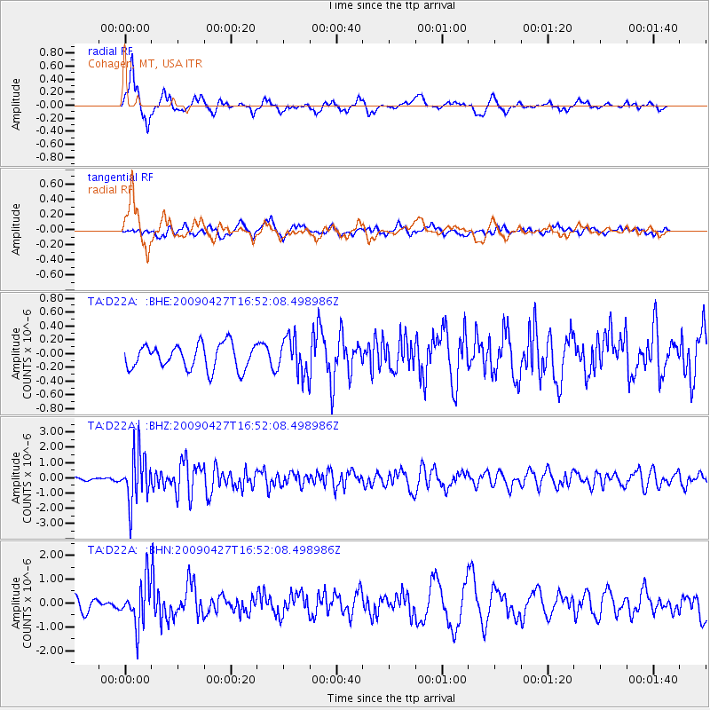
D22A Cohagen, MT, USA - Earthquake Result Viewer
*The percent match for this event was below the threshold and hence no stack was calculated.
| Earthquake location: |
Guerrero, Mexico |
| Earthquake latitude/longitude: |
17.0/-99.4 |
| Earthquake time(UTC): |
2009/04/27 (117) 16:46:28 GMT |
| Earthquake Depth: |
35 km |
| Earthquake Magnitude: |
5.7 MB, 5.4 MS, 5.8 MW, 5.8 MW |
| Earthquake Catalog/Contributor: |
WHDF/NEIC |
|
| Network: |
TA USArray Transportable Network (new EarthScope stations) |
| Station: |
D22A Cohagen, MT, USA |
| Lat/Lon: |
47.15 N/106.18 W |
| Elevation: |
791 m |
|
| Distance: |
30.5 deg |
| Az: |
350.94 deg |
| Baz: |
167.248 deg |
| Ray Param: |
$rayparam |
*The percent match for this event was below the threshold and hence was not used in the summary stack. |
|
| Radial Match: |
80.67355 % |
| Radial Bump: |
351 |
| Transverse Match: |
69.90545 % |
| Transverse Bump: |
400 |
| SOD ConfigId: |
2658 |
| Insert Time: |
2010-03-06 21:32:07.258 +0000 |
| GWidth: |
2.5 |
| Max Bumps: |
400 |
| Tol: |
0.001 |
|
Signal To Noise
| Channel | StoN | STA | LTA |
| TA:D22A: :BHZ:20090427T16:52:08.498986Z | 10.423922 | 1.6207649E-6 | 1.5548515E-7 |
| TA:D22A: :BHN:20090427T16:52:08.498986Z | 3.9310303 | 9.344548E-7 | 2.3771244E-7 |
| TA:D22A: :BHE:20090427T16:52:08.498986Z | 1.4901423 | 2.6739812E-7 | 1.7944467E-7 |
| Arrivals |
| Ps | |
| PpPs | |
| PsPs/PpSs | |


