You are here: Home > Network List > TA - USArray Transportable Network (new EarthScope stations) Stations List
> Station D22A Cohagen, MT, USA > Earthquake Result Viewer
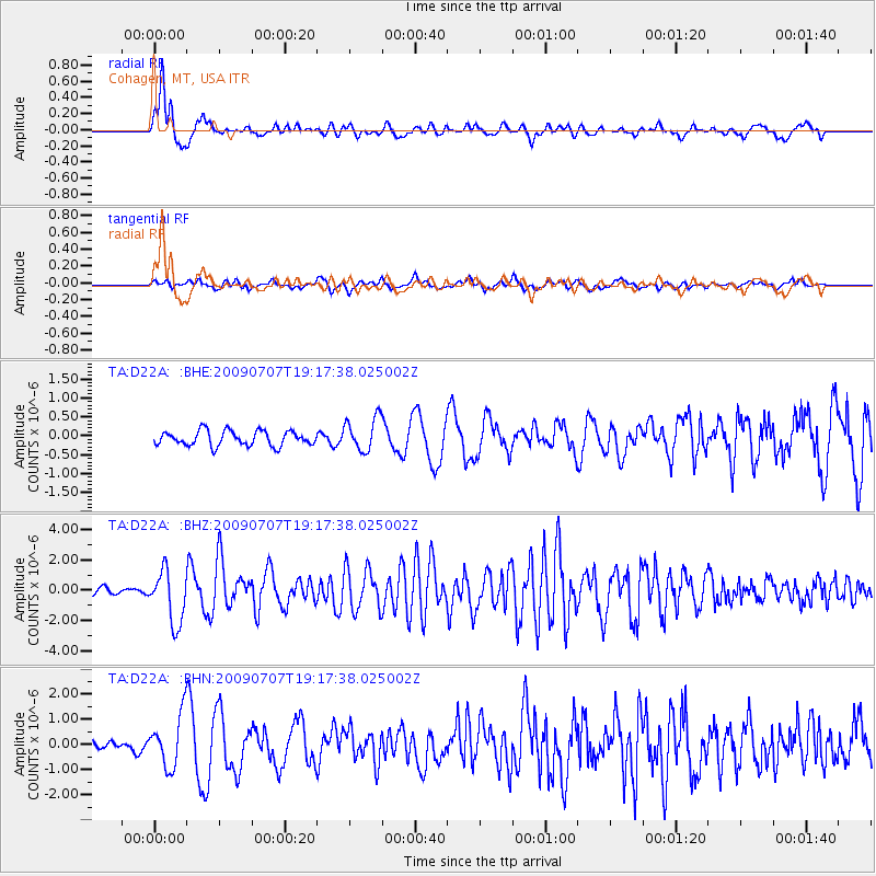
D22A Cohagen, MT, USA - Earthquake Result Viewer
*The percent match for this event was below the threshold and hence no stack was calculated.
| Earthquake location: |
Baffin Bay |
| Earthquake latitude/longitude: |
75.4/-72.5 |
| Earthquake time(UTC): |
2009/07/07 (188) 19:11:46 GMT |
| Earthquake Depth: |
19 km |
| Earthquake Magnitude: |
5.9 MB, 5.7 MS, 6.1 MW, 6.0 MW |
| Earthquake Catalog/Contributor: |
WHDF/NEIC |
|
| Network: |
TA USArray Transportable Network (new EarthScope stations) |
| Station: |
D22A Cohagen, MT, USA |
| Lat/Lon: |
47.15 N/106.18 W |
| Elevation: |
791 m |
|
| Distance: |
31.7 deg |
| Az: |
226.235 deg |
| Baz: |
15.621 deg |
| Ray Param: |
$rayparam |
*The percent match for this event was below the threshold and hence was not used in the summary stack. |
|
| Radial Match: |
82.859146 % |
| Radial Bump: |
400 |
| Transverse Match: |
63.275616 % |
| Transverse Bump: |
400 |
| SOD ConfigId: |
2648 |
| Insert Time: |
2010-03-06 21:32:10.484 +0000 |
| GWidth: |
2.5 |
| Max Bumps: |
400 |
| Tol: |
0.001 |
|
Signal To Noise
| Channel | StoN | STA | LTA |
| TA:D22A: :BHZ:20090707T19:17:38.025002Z | 8.844576 | 1.7297796E-6 | 1.9557517E-7 |
| TA:D22A: :BHN:20090707T19:17:38.025002Z | 3.3018982 | 1.0299173E-6 | 3.1191672E-7 |
| TA:D22A: :BHE:20090707T19:17:38.025002Z | 2.2828658 | 4.4322456E-7 | 1.9415269E-7 |
| Arrivals |
| Ps | |
| PpPs | |
| PsPs/PpSs | |


