You are here: Home > Network List > TA - USArray Transportable Network (new EarthScope stations) Stations List
> Station D22A Cohagen, MT, USA > Earthquake Result Viewer
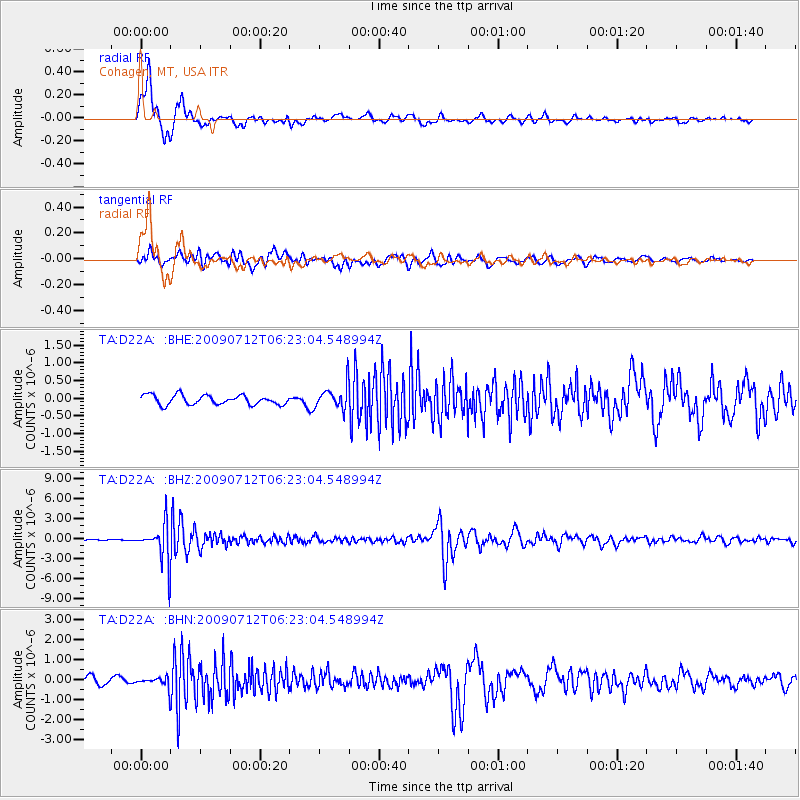
D22A Cohagen, MT, USA - Earthquake Result Viewer
*The percent match for this event was below the threshold and hence no stack was calculated.
| Earthquake location: |
Southern Peru |
| Earthquake latitude/longitude: |
-15.0/-70.4 |
| Earthquake time(UTC): |
2009/07/12 (193) 06:12:47 GMT |
| Earthquake Depth: |
199 km |
| Earthquake Magnitude: |
5.7 MB, 6.1 MW, 6.1 MW |
| Earthquake Catalog/Contributor: |
WHDF/NEIC |
|
| Network: |
TA USArray Transportable Network (new EarthScope stations) |
| Station: |
D22A Cohagen, MT, USA |
| Lat/Lon: |
47.15 N/106.18 W |
| Elevation: |
791 m |
|
| Distance: |
69.7 deg |
| Az: |
334.849 deg |
| Baz: |
143.014 deg |
| Ray Param: |
$rayparam |
*The percent match for this event was below the threshold and hence was not used in the summary stack. |
|
| Radial Match: |
91.93709 % |
| Radial Bump: |
360 |
| Transverse Match: |
73.66608 % |
| Transverse Bump: |
400 |
| SOD ConfigId: |
2648 |
| Insert Time: |
2010-03-06 21:32:11.104 +0000 |
| GWidth: |
2.5 |
| Max Bumps: |
400 |
| Tol: |
0.001 |
|
Signal To Noise
| Channel | StoN | STA | LTA |
| TA:D22A: :BHZ:20090712T06:23:04.548994Z | 31.876945 | 2.7863484E-6 | 8.740952E-8 |
| TA:D22A: :BHN:20090712T06:23:04.548994Z | 1.6566559 | 2.7208384E-7 | 1.6423678E-7 |
| TA:D22A: :BHE:20090712T06:23:04.548994Z | 2.4602427 | 3.2959258E-7 | 1.339675E-7 |
| Arrivals |
| Ps | |
| PpPs | |
| PsPs/PpSs | |


