You are here: Home > Network List > CN - Canadian National Seismograph Network Stations List
> Station POIN Pond Inlet, NU, CA > Earthquake Result Viewer
POIN Pond Inlet, NU, CA - Earthquake Result Viewer
| Earthquake location: |
Taiwan |
| Earthquake latitude/longitude: |
24.0/121.7 |
| Earthquake time(UTC): |
2019/04/18 (108) 05:01:06 GMT |
| Earthquake Depth: |
20 km |
| Earthquake Magnitude: |
6.1 Mww |
| Earthquake Catalog/Contributor: |
NEIC PDE/us |
|
| Network: |
CN Canadian National Seismograph Network |
| Station: |
POIN Pond Inlet, NU, CA |
| Lat/Lon: |
72.70 N/77.96 W |
| Elevation: |
21 m |
|
| Distance: |
82.6 deg |
| Az: |
5.824 deg |
| Baz: |
341.929 deg |
| Ray Param: |
0.046727978 |
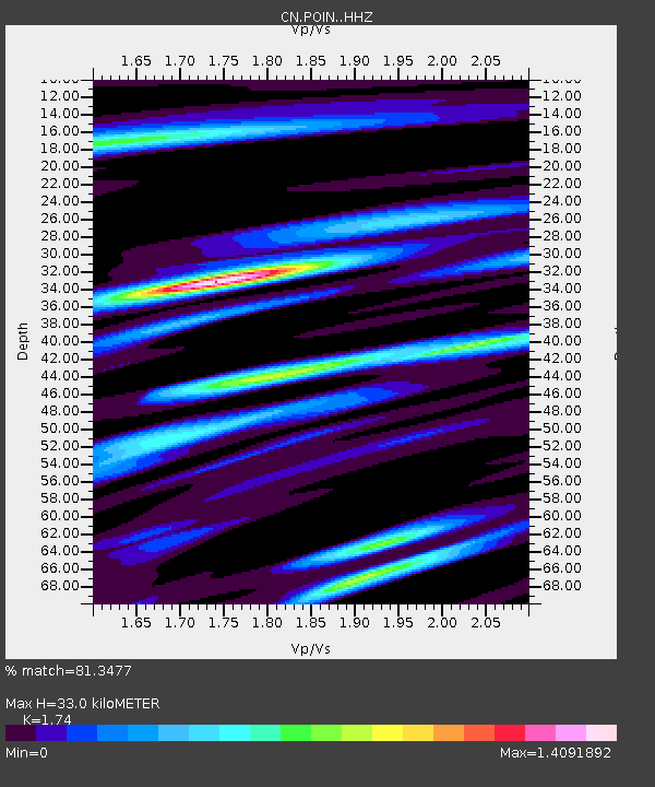
| Estimated Moho Depth: |
33.0 km |
| Estimated Crust Vp/Vs: |
1.74 |
| Assumed Crust Vp: |
6.367 km/s |
| Estimated Crust Vs: |
3.659 km/s |
| Estimated Crust Poisson's Ratio: |
0.25 |
|
| Radial Match: |
81.3477 % |
| Radial Bump: |
377 |
| Transverse Match: |
72.06744 % |
| Transverse Bump: |
400 |
| SOD ConfigId: |
13570011 |
| Insert Time: |
2019-05-02 23:09:03.915 +0000 |
| GWidth: |
2.5 |
| Max Bumps: |
400 |
| Tol: |
0.001 |
|

Signal To Noise
| Channel | StoN | STA | LTA |
| CN:POIN: :HHZ:20190418T05:12:56.870026Z | 17.020973 | 2.387719E-6 | 1.4028099E-7 |
| CN:POIN: :HHN:20190418T05:12:56.870026Z | 6.3222566 | 9.275118E-7 | 1.4670582E-7 |
| CN:POIN: :HHE:20190418T05:12:56.870026Z | 3.8408222 | 6.444619E-7 | 1.6779269E-7 |
| Arrivals |
| Ps | 3.9 SECOND |
| PpPs | 14 SECOND |
| PsPs/PpSs | 18 SECOND |


