You are here: Home > Network List > TS - TERRAscope (Southern California Seismic Network) Stations List
> Station DGR Domenigoni Valley Reservior, California, USA > Earthquake Result Viewer
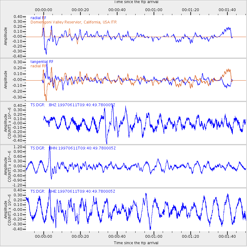
DGR Domenigoni Valley Reservior, California, USA - Earthquake Result Viewer
*The percent match for this event was below the threshold and hence no stack was calculated.
| Earthquake location: |
South Of Fiji Islands |
| Earthquake latitude/longitude: |
-24.0/-177.5 |
| Earthquake time(UTC): |
1997/06/11 (162) 09:29:23 GMT |
| Earthquake Depth: |
164 km |
| Earthquake Magnitude: |
5.9 UNKNOWN, 5.4 MB, 5.5 MB |
| Earthquake Catalog/Contributor: |
WHDF/NEIC |
|
| Network: |
TS TERRAscope (Southern California Seismic Network) |
| Station: |
DGR Domenigoni Valley Reservior, California, USA |
| Lat/Lon: |
33.65 N/117.01 W |
| Elevation: |
700 m |
|
| Distance: |
81.2 deg |
| Az: |
47.277 deg |
| Baz: |
233.673 deg |
| Ray Param: |
$rayparam |
*The percent match for this event was below the threshold and hence was not used in the summary stack. |
|
| Radial Match: |
74.659515 % |
| Radial Bump: |
400 |
| Transverse Match: |
57.20582 % |
| Transverse Bump: |
343 |
| SOD ConfigId: |
4480 |
| Insert Time: |
2010-02-26 14:10:40.419 +0000 |
| GWidth: |
2.5 |
| Max Bumps: |
400 |
| Tol: |
0.001 |
|
Signal To Noise
| Channel | StoN | STA | LTA |
| TS:DGR: :BHN:19970611T09:40:49.780005Z | 3.7771893 | 4.865985E-7 | 1.2882555E-7 |
| TS:DGR: :BHE:19970611T09:40:49.780005Z | 1.1487678 | 1.9931404E-7 | 1.7350247E-7 |
| TS:DGR: :BHZ:19970611T09:40:49.780005Z | 2.3827448 | 2.1835984E-7 | 9.164214E-8 |
| Arrivals |
| Ps | |
| PpPs | |
| PsPs/PpSs | |


