You are here: Home > Network List > TA - USArray Transportable Network (new EarthScope stations) Stations List
> Station D22A Cohagen, MT, USA > Earthquake Result Viewer
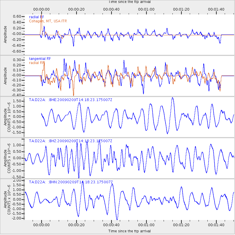
D22A Cohagen, MT, USA - Earthquake Result Viewer
*The percent match for this event was below the threshold and hence no stack was calculated.
| Earthquake location: |
Near Coast Of Northern Peru |
| Earthquake latitude/longitude: |
-6.6/-81.2 |
| Earthquake time(UTC): |
2009/02/09 (040) 14:09:02 GMT |
| Earthquake Depth: |
15 km |
| Earthquake Magnitude: |
5.5 MB, 5.5 MS, 6.0 MW, 5.9 MW |
| Earthquake Catalog/Contributor: |
WHDF/NEIC |
|
| Network: |
TA USArray Transportable Network (new EarthScope stations) |
| Station: |
D22A Cohagen, MT, USA |
| Lat/Lon: |
47.15 N/106.18 W |
| Elevation: |
791 m |
|
| Distance: |
57.9 deg |
| Az: |
340.069 deg |
| Baz: |
150.25 deg |
| Ray Param: |
$rayparam |
*The percent match for this event was below the threshold and hence was not used in the summary stack. |
|
| Radial Match: |
57.662888 % |
| Radial Bump: |
400 |
| Transverse Match: |
53.40567 % |
| Transverse Bump: |
337 |
| SOD ConfigId: |
2658 |
| Insert Time: |
2010-03-06 21:32:13.935 +0000 |
| GWidth: |
2.5 |
| Max Bumps: |
400 |
| Tol: |
0.001 |
|
Signal To Noise
| Channel | StoN | STA | LTA |
| TA:D22A: :BHZ:20090209T14:18:23.175007Z | 3.3987594 | 6.449488E-7 | 1.8976007E-7 |
| TA:D22A: :BHN:20090209T14:18:23.175007Z | 0.32681364 | 1.8539336E-7 | 5.672755E-7 |
| TA:D22A: :BHE:20090209T14:18:23.175007Z | 0.36537772 | 2.2877336E-7 | 6.261283E-7 |
| Arrivals |
| Ps | |
| PpPs | |
| PsPs/PpSs | |


