You are here: Home > Network List > TA - USArray Transportable Network (new EarthScope stations) Stations List
> Station D22A Cohagen, MT, USA > Earthquake Result Viewer
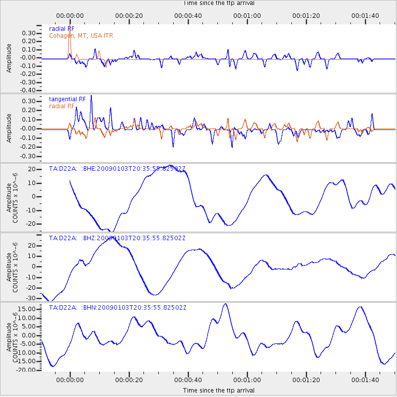
D22A Cohagen, MT, USA - Earthquake Result Viewer
*The percent match for this event was below the threshold and hence no stack was calculated.
| Earthquake location: |
Hindu Kush Region, Afghanistan |
| Earthquake latitude/longitude: |
36.4/70.7 |
| Earthquake time(UTC): |
2009/01/03 (003) 20:23:20 GMT |
| Earthquake Depth: |
205 km |
| Earthquake Magnitude: |
5.8 MB |
| Earthquake Catalog/Contributor: |
WHDF/NEIC |
|
| Network: |
TA USArray Transportable Network (new EarthScope stations) |
| Station: |
D22A Cohagen, MT, USA |
| Lat/Lon: |
47.15 N/106.18 W |
| Elevation: |
791 m |
|
| Distance: |
96.8 deg |
| Az: |
357.885 deg |
| Baz: |
2.499 deg |
| Ray Param: |
$rayparam |
*The percent match for this event was below the threshold and hence was not used in the summary stack. |
|
| Radial Match: |
59.19289 % |
| Radial Bump: |
400 |
| Transverse Match: |
90.71473 % |
| Transverse Bump: |
362 |
| SOD ConfigId: |
2834 |
| Insert Time: |
2010-03-06 21:32:29.401 +0000 |
| GWidth: |
2.5 |
| Max Bumps: |
400 |
| Tol: |
0.001 |
|
Signal To Noise
| Channel | StoN | STA | LTA |
| TA:D22A: :BHZ:20090103T20:35:55.82502Z | 0.30502898 | 6.4723067E-6 | 2.1218662E-5 |
| TA:D22A: :BHN:20090103T20:35:55.82502Z | 0.59788305 | 5.1085867E-6 | 8.544458E-6 |
| TA:D22A: :BHE:20090103T20:35:55.82502Z | 3.0245228 | 3.242009E-5 | 1.0719075E-5 |
| Arrivals |
| Ps | |
| PpPs | |
| PsPs/PpSs | |


