You are here: Home > Network List > TS - TERRAscope (Southern California Seismic Network) Stations List
> Station DGR Domenigoni Valley Reservior, California, USA > Earthquake Result Viewer
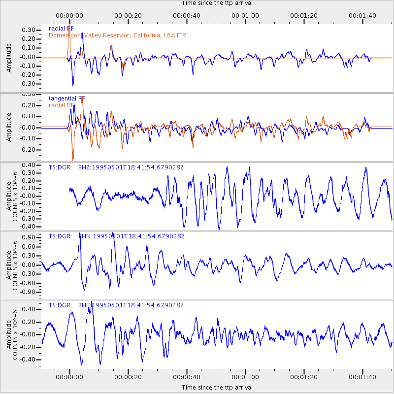
DGR Domenigoni Valley Reservior, California, USA - Earthquake Result Viewer
*The percent match for this event was below the threshold and hence no stack was calculated.
| Earthquake location: |
Solomon Islands |
| Earthquake latitude/longitude: |
-10.6/161.4 |
| Earthquake time(UTC): |
1995/05/01 (121) 18:29:41 GMT |
| Earthquake Depth: |
94 km |
| Earthquake Magnitude: |
5.5 MB, 6.0 UNKNOWN, 5.8 MW |
| Earthquake Catalog/Contributor: |
WHDF/NEIC |
|
| Network: |
TS TERRAscope (Southern California Seismic Network) |
| Station: |
DGR Domenigoni Valley Reservior, California, USA |
| Lat/Lon: |
33.65 N/117.01 W |
| Elevation: |
700 m |
|
| Distance: |
88.9 deg |
| Az: |
55.626 deg |
| Baz: |
256.584 deg |
| Ray Param: |
$rayparam |
*The percent match for this event was below the threshold and hence was not used in the summary stack. |
|
| Radial Match: |
67.38582 % |
| Radial Bump: |
400 |
| Transverse Match: |
44.083313 % |
| Transverse Bump: |
400 |
| SOD ConfigId: |
4480 |
| Insert Time: |
2010-02-26 14:10:40.803 +0000 |
| GWidth: |
2.5 |
| Max Bumps: |
400 |
| Tol: |
0.001 |
|
Signal To Noise
| Channel | StoN | STA | LTA |
| TS:DGR: :BHN:19950501T18:41:54.679028Z | 3.8909638 | 4.278975E-7 | 1.0997211E-7 |
| TS:DGR: :BHE:19950501T18:41:54.679028Z | 3.0054739 | 2.8882053E-7 | 9.609817E-8 |
| TS:DGR: :BHZ:19950501T18:41:54.679028Z | 1.6788986 | 1.0859702E-7 | 6.468349E-8 |
| Arrivals |
| Ps | |
| PpPs | |
| PsPs/PpSs | |


