You are here: Home > Network List > TA - USArray Transportable Network (new EarthScope stations) Stations List
> Station D22A Cohagen, MT, USA > Earthquake Result Viewer
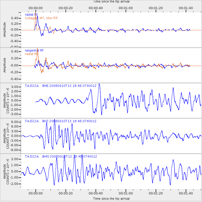
D22A Cohagen, MT, USA - Earthquake Result Viewer
*The percent match for this event was below the threshold and hence no stack was calculated.
| Earthquake location: |
Central Mid-Atlantic Ridge |
| Earthquake latitude/longitude: |
8.1/-38.7 |
| Earthquake time(UTC): |
2008/09/10 (254) 13:08:14 GMT |
| Earthquake Depth: |
10 km |
| Earthquake Magnitude: |
6.3 MB, 6.5 MS, 6.6 MW, 6.6 MW |
| Earthquake Catalog/Contributor: |
WHDF/NEIC |
|
| Network: |
TA USArray Transportable Network (new EarthScope stations) |
| Station: |
D22A Cohagen, MT, USA |
| Lat/Lon: |
47.15 N/106.18 W |
| Elevation: |
791 m |
|
| Distance: |
68.8 deg |
| Az: |
317.463 deg |
| Baz: |
101.251 deg |
| Ray Param: |
$rayparam |
*The percent match for this event was below the threshold and hence was not used in the summary stack. |
|
| Radial Match: |
88.4505 % |
| Radial Bump: |
370 |
| Transverse Match: |
79.67591 % |
| Transverse Bump: |
383 |
| SOD ConfigId: |
2560 |
| Insert Time: |
2010-03-06 21:32:32.042 +0000 |
| GWidth: |
2.5 |
| Max Bumps: |
400 |
| Tol: |
0.001 |
|
Signal To Noise
| Channel | StoN | STA | LTA |
| TA:D22A: :BHZ:20080910T13:18:48.074001Z | 2.297987 | 5.145312E-7 | 2.239052E-7 |
| TA:D22A: :BHN:20080910T13:18:48.074001Z | 0.84730864 | 2.831705E-7 | 3.3419994E-7 |
| TA:D22A: :BHE:20080910T13:18:48.074001Z | 0.8783195 | 3.519332E-7 | 4.0068926E-7 |
| Arrivals |
| Ps | |
| PpPs | |
| PsPs/PpSs | |


