You are here: Home > Network List > TA - USArray Transportable Network (new EarthScope stations) Stations List
> Station D22A Cohagen, MT, USA > Earthquake Result Viewer
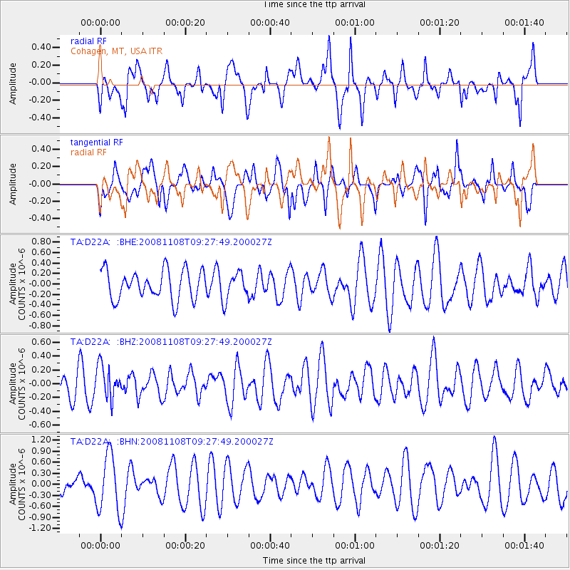
D22A Cohagen, MT, USA - Earthquake Result Viewer
*The percent match for this event was below the threshold and hence no stack was calculated.
| Earthquake location: |
Tonga Islands |
| Earthquake latitude/longitude: |
-15.2/-174.2 |
| Earthquake time(UTC): |
2008/11/08 (313) 09:15:51 GMT |
| Earthquake Depth: |
140 km |
| Earthquake Magnitude: |
5.5 MW, 5.3 MB |
| Earthquake Catalog/Contributor: |
WHDF/NEIC |
|
| Network: |
TA USArray Transportable Network (new EarthScope stations) |
| Station: |
D22A Cohagen, MT, USA |
| Lat/Lon: |
47.15 N/106.18 W |
| Elevation: |
791 m |
|
| Distance: |
86.8 deg |
| Az: |
39.343 deg |
| Baz: |
243.725 deg |
| Ray Param: |
$rayparam |
*The percent match for this event was below the threshold and hence was not used in the summary stack. |
|
| Radial Match: |
64.381935 % |
| Radial Bump: |
400 |
| Transverse Match: |
46.13504 % |
| Transverse Bump: |
400 |
| SOD ConfigId: |
2658 |
| Insert Time: |
2010-03-06 21:32:32.816 +0000 |
| GWidth: |
2.5 |
| Max Bumps: |
400 |
| Tol: |
0.001 |
|
Signal To Noise
| Channel | StoN | STA | LTA |
| TA:D22A: :BHZ:20081108T09:27:49.200027Z | 0.9291872 | 2.4187352E-7 | 2.6030656E-7 |
| TA:D22A: :BHN:20081108T09:27:49.200027Z | 2.4992573 | 7.9131615E-7 | 3.1662051E-7 |
| TA:D22A: :BHE:20081108T09:27:49.200027Z | 0.9149797 | 2.547722E-7 | 2.7844575E-7 |
| Arrivals |
| Ps | |
| PpPs | |
| PsPs/PpSs | |


