You are here: Home > Network List > TA - USArray Transportable Network (new EarthScope stations) Stations List
> Station D22A Cohagen, MT, USA > Earthquake Result Viewer
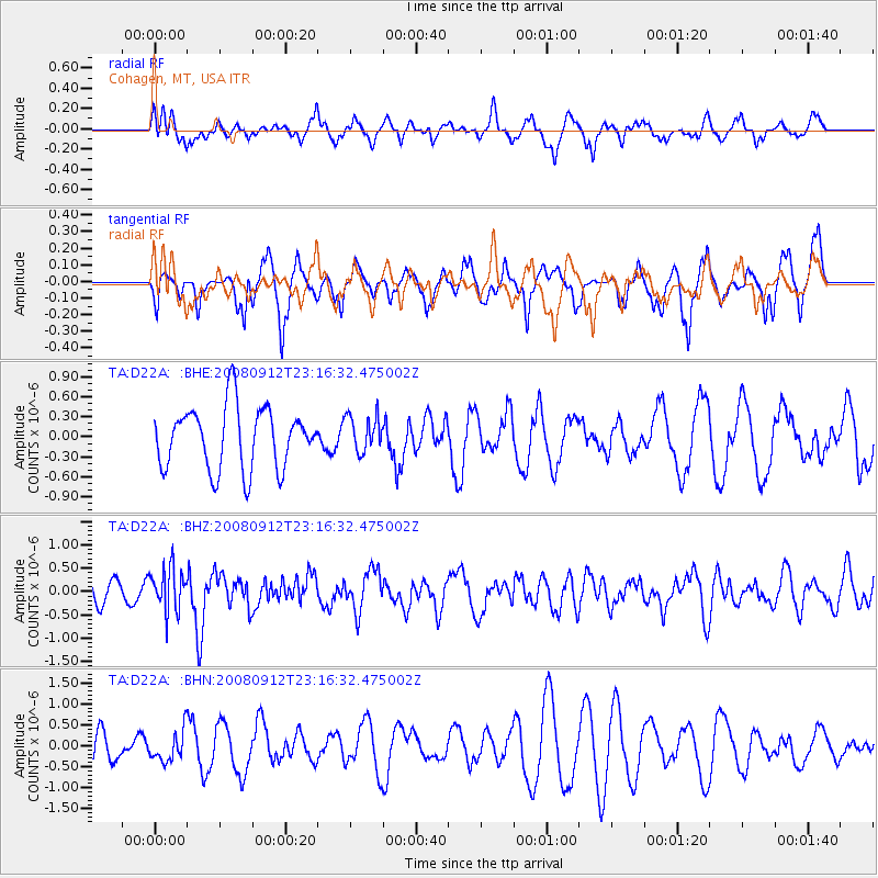
D22A Cohagen, MT, USA - Earthquake Result Viewer
*The percent match for this event was below the threshold and hence no stack was calculated.
| Earthquake location: |
Komandorskiye Ostrova Region |
| Earthquake latitude/longitude: |
56.3/164.1 |
| Earthquake time(UTC): |
2008/09/12 (256) 23:07:50 GMT |
| Earthquake Depth: |
9.3 km |
| Earthquake Magnitude: |
5.5 MB, 5.7 MS, 5.9 MW, 5.9 MW |
| Earthquake Catalog/Contributor: |
WHDF/NEIC |
|
| Network: |
TA USArray Transportable Network (new EarthScope stations) |
| Station: |
D22A Cohagen, MT, USA |
| Lat/Lon: |
47.15 N/106.18 W |
| Elevation: |
791 m |
|
| Distance: |
52.5 deg |
| Az: |
59.336 deg |
| Baz: |
315.381 deg |
| Ray Param: |
$rayparam |
*The percent match for this event was below the threshold and hence was not used in the summary stack. |
|
| Radial Match: |
58.87177 % |
| Radial Bump: |
400 |
| Transverse Match: |
52.504684 % |
| Transverse Bump: |
335 |
| SOD ConfigId: |
2560 |
| Insert Time: |
2010-03-06 21:32:33.655 +0000 |
| GWidth: |
2.5 |
| Max Bumps: |
400 |
| Tol: |
0.001 |
|
Signal To Noise
| Channel | StoN | STA | LTA |
| TA:D22A: :BHZ:20080912T23:16:32.475002Z | 2.3777158 | 4.5766697E-7 | 1.9248179E-7 |
| TA:D22A: :BHN:20080912T23:16:32.475002Z | 0.8729868 | 3.5213566E-7 | 4.0336883E-7 |
| TA:D22A: :BHE:20080912T23:16:32.475002Z | 0.58495796 | 2.7224536E-7 | 4.6541012E-7 |
| Arrivals |
| Ps | |
| PpPs | |
| PsPs/PpSs | |


