You are here: Home > Network List > TS - TERRAscope (Southern California Seismic Network) Stations List
> Station DGR Domenigoni Valley Reservior, California, USA > Earthquake Result Viewer
DGR Domenigoni Valley Reservior, California, USA - Earthquake Result Viewer
*The percent match for this event was below the threshold and hence no stack was calculated.
| Earthquake location: |
Bonin Islands, Japan Region |
| Earthquake latitude/longitude: |
27.7/139.7 |
| Earthquake time(UTC): |
1996/06/26 (178) 03:22:03 GMT |
| Earthquake Depth: |
469 km |
| Earthquake Magnitude: |
5.5 MB, 6.3 UNKNOWN, 5.4 MB |
| Earthquake Catalog/Contributor: |
WHDF/NEIC |
|
| Network: |
TS TERRAscope (Southern California Seismic Network) |
| Station: |
DGR Domenigoni Valley Reservior, California, USA |
| Lat/Lon: |
33.65 N/117.01 W |
| Elevation: |
700 m |
|
| Distance: |
85.1 deg |
| Az: |
54.585 deg |
| Baz: |
299.994 deg |
| Ray Param: |
$rayparam |
*The percent match for this event was below the threshold and hence was not used in the summary stack. |
|
| Radial Match: |
61.335804 % |
| Radial Bump: |
322 |
| Transverse Match: |
56.80414 % |
| Transverse Bump: |
400 |
| SOD ConfigId: |
4480 |
| Insert Time: |
2010-02-26 14:10:41.196 +0000 |
| GWidth: |
2.5 |
| Max Bumps: |
400 |
| Tol: |
0.001 |
|
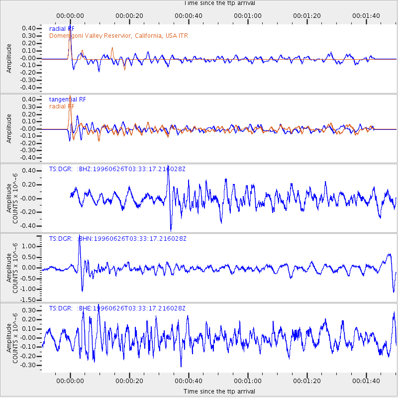
Signal To Noise
| Channel | StoN | STA | LTA |
| TS:DGR: :BHN:19960626T03:33:17.216028Z | 8.857241 | 5.21086E-7 | 5.8831642E-8 |
| TS:DGR: :BHE:19960626T03:33:17.216028Z | 2.0978582 | 1.250087E-7 | 5.9588732E-8 |
| TS:DGR: :BHZ:19960626T03:33:17.216028Z | 2.5660434 | 1.9318429E-7 | 7.528489E-8 |
| Arrivals |
| Ps | |
| PpPs | |
| PsPs/PpSs | |


