You are here: Home > Network List > TA - USArray Transportable Network (new EarthScope stations) Stations List
> Station D22A Cohagen, MT, USA > Earthquake Result Viewer
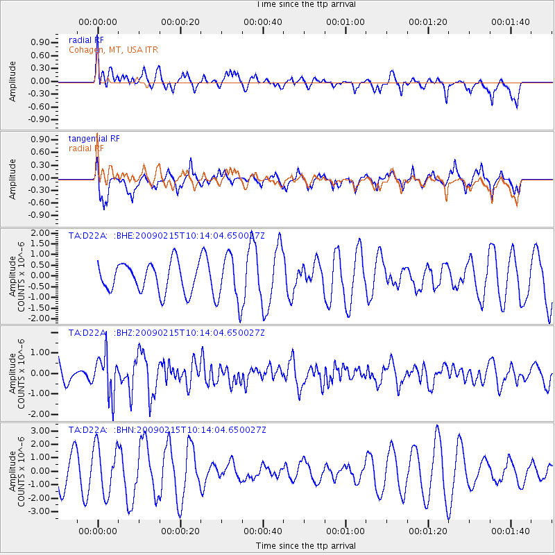
D22A Cohagen, MT, USA - Earthquake Result Viewer
*The percent match for this event was below the threshold and hence no stack was calculated.
| Earthquake location: |
Near Coast Of Northern Peru |
| Earthquake latitude/longitude: |
-5.9/-80.9 |
| Earthquake time(UTC): |
2009/02/15 (046) 10:04:49 GMT |
| Earthquake Depth: |
21 km |
| Earthquake Magnitude: |
5.8 MB, 5.7 MS, 6.1 MW, 6.1 MW |
| Earthquake Catalog/Contributor: |
WHDF/NEIC |
|
| Network: |
TA USArray Transportable Network (new EarthScope stations) |
| Station: |
D22A Cohagen, MT, USA |
| Lat/Lon: |
47.15 N/106.18 W |
| Elevation: |
791 m |
|
| Distance: |
57.3 deg |
| Az: |
339.733 deg |
| Baz: |
149.676 deg |
| Ray Param: |
$rayparam |
*The percent match for this event was below the threshold and hence was not used in the summary stack. |
|
| Radial Match: |
50.683575 % |
| Radial Bump: |
400 |
| Transverse Match: |
70.63595 % |
| Transverse Bump: |
369 |
| SOD ConfigId: |
2658 |
| Insert Time: |
2010-03-06 21:32:43.754 +0000 |
| GWidth: |
2.5 |
| Max Bumps: |
400 |
| Tol: |
0.001 |
|
Signal To Noise
| Channel | StoN | STA | LTA |
| TA:D22A: :BHZ:20090215T10:14:04.650027Z | 1.7580907 | 9.951957E-7 | 5.660662E-7 |
| TA:D22A: :BHN:20090215T10:14:04.650027Z | 1.325969 | 1.8208378E-6 | 1.373213E-6 |
| TA:D22A: :BHE:20090215T10:14:04.650027Z | 1.6812452 | 1.1181558E-6 | 6.6507596E-7 |
| Arrivals |
| Ps | |
| PpPs | |
| PsPs/PpSs | |


