You are here: Home > Network List > TA - USArray Transportable Network (new EarthScope stations) Stations List
> Station A36M Sachs Harbour, NT, CAN > Earthquake Result Viewer
A36M Sachs Harbour, NT, CAN - Earthquake Result Viewer
| Earthquake location: |
Taiwan |
| Earthquake latitude/longitude: |
24.0/121.7 |
| Earthquake time(UTC): |
2019/04/18 (108) 05:01:06 GMT |
| Earthquake Depth: |
20 km |
| Earthquake Magnitude: |
6.1 Mww |
| Earthquake Catalog/Contributor: |
NEIC PDE/us |
|
| Network: |
TA USArray Transportable Network (new EarthScope stations) |
| Station: |
A36M Sachs Harbour, NT, CAN |
| Lat/Lon: |
71.99 N/125.25 W |
| Elevation: |
32 m |
|
| Distance: |
74.2 deg |
| Az: |
17.31 deg |
| Baz: |
298.988 deg |
| Ray Param: |
0.05249341 |
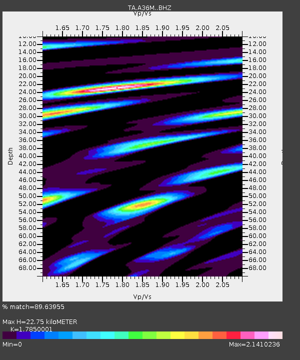
| Estimated Moho Depth: |
22.75 km |
| Estimated Crust Vp/Vs: |
1.79 |
| Assumed Crust Vp: |
6.24 km/s |
| Estimated Crust Vs: |
3.496 km/s |
| Estimated Crust Poisson's Ratio: |
0.27 |
|
| Radial Match: |
89.63955 % |
| Radial Bump: |
400 |
| Transverse Match: |
74.78862 % |
| Transverse Bump: |
400 |
| SOD ConfigId: |
13570011 |
| Insert Time: |
2019-05-02 23:12:24.934 +0000 |
| GWidth: |
2.5 |
| Max Bumps: |
400 |
| Tol: |
0.001 |
|

Signal To Noise
| Channel | StoN | STA | LTA |
| TA:A36M: :BHZ:20190418T05:12:10.274995Z | 11.900276 | 2.632378E-6 | 2.2120311E-7 |
| TA:A36M: :BHN:20190418T05:12:10.274995Z | 2.7340493 | 5.656064E-7 | 2.0687499E-7 |
| TA:A36M: :BHE:20190418T05:12:10.274995Z | 4.4493747 | 1.3188692E-6 | 2.9641674E-7 |
| Arrivals |
| Ps | 3.0 SECOND |
| PpPs | 9.8 SECOND |
| PsPs/PpSs | 13 SECOND |


