You are here: Home > Network List > TA - USArray Transportable Network (new EarthScope stations) Stations List
> Station B18K Kokolik River, AK, USA > Earthquake Result Viewer
B18K Kokolik River, AK, USA - Earthquake Result Viewer
| Earthquake location: |
Taiwan |
| Earthquake latitude/longitude: |
24.0/121.7 |
| Earthquake time(UTC): |
2019/04/18 (108) 05:01:06 GMT |
| Earthquake Depth: |
20 km |
| Earthquake Magnitude: |
6.1 Mww |
| Earthquake Catalog/Contributor: |
NEIC PDE/us |
|
| Network: |
TA USArray Transportable Network (new EarthScope stations) |
| Station: |
B18K Kokolik River, AK, USA |
| Lat/Lon: |
69.36 N/161.80 W |
| Elevation: |
222 m |
|
| Distance: |
63.0 deg |
| Az: |
22.757 deg |
| Baz: |
266.381 deg |
| Ray Param: |
0.059826512 |
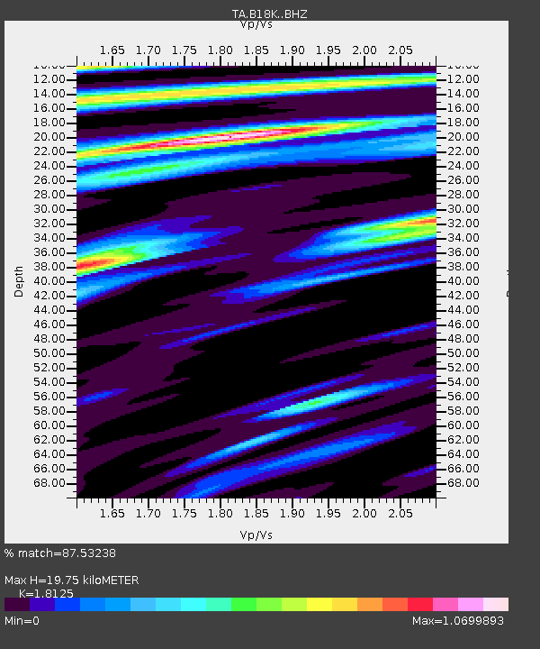
| Estimated Moho Depth: |
19.75 km |
| Estimated Crust Vp/Vs: |
1.81 |
| Assumed Crust Vp: |
5.906 km/s |
| Estimated Crust Vs: |
3.259 km/s |
| Estimated Crust Poisson's Ratio: |
0.28 |
|
| Radial Match: |
87.53238 % |
| Radial Bump: |
400 |
| Transverse Match: |
76.30934 % |
| Transverse Bump: |
400 |
| SOD ConfigId: |
13570011 |
| Insert Time: |
2019-05-02 23:12:25.231 +0000 |
| GWidth: |
2.5 |
| Max Bumps: |
400 |
| Tol: |
0.001 |
|
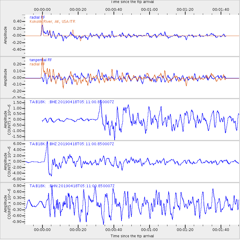
Signal To Noise
| Channel | StoN | STA | LTA |
| TA:B18K: :BHZ:20190418T05:11:00.850007Z | 19.87264 | 3.2138378E-6 | 1.6172173E-7 |
| TA:B18K: :BHN:20190418T05:11:00.850007Z | 1.9924301 | 2.522594E-7 | 1.2660891E-7 |
| TA:B18K: :BHE:20190418T05:11:00.850007Z | 7.2304 | 7.0261876E-7 | 9.717564E-8 |
| Arrivals |
| Ps | 2.8 SECOND |
| PpPs | 9.1 SECOND |
| PsPs/PpSs | 12 SECOND |


