You are here: Home > Network List > GS - US Geological Survey Networks Stations List
> Station KAN08 Pence Farm, Harper, KS, USA > Earthquake Result Viewer
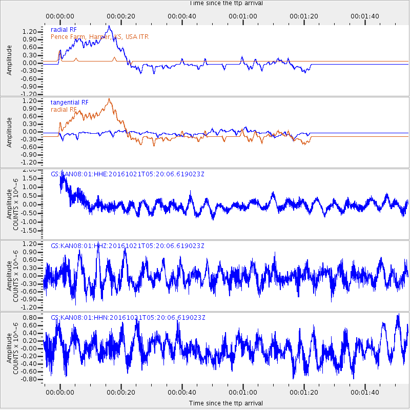
KAN08 Pence Farm, Harper, KS, USA - Earthquake Result Viewer
*The percent match for this event was below the threshold and hence no stack was calculated.
| Earthquake location: |
Western Honshu, Japan |
| Earthquake latitude/longitude: |
35.4/133.8 |
| Earthquake time(UTC): |
2016/10/21 (295) 05:07:23 GMT |
| Earthquake Depth: |
10 km |
| Earthquake Magnitude: |
6.2 MWW, 6.6 MI |
| Earthquake Catalog/Contributor: |
NEIC PDE/NEIC COMCAT |
|
| Network: |
GS US Geological Survey Networks |
| Station: |
KAN08 Pence Farm, Harper, KS, USA |
| Lat/Lon: |
37.23 N/97.97 W |
| Elevation: |
375 m |
|
| Distance: |
93.2 deg |
| Az: |
38.906 deg |
| Baz: |
319.974 deg |
| Ray Param: |
$rayparam |
*The percent match for this event was below the threshold and hence was not used in the summary stack. |
|
| Radial Match: |
61.89968 % |
| Radial Bump: |
400 |
| Transverse Match: |
65.6093 % |
| Transverse Bump: |
400 |
| SOD ConfigId: |
1815711 |
| Insert Time: |
2016-11-04 05:09:05.093 +0000 |
| GWidth: |
2.5 |
| Max Bumps: |
400 |
| Tol: |
0.001 |
|
Signal To Noise
| Channel | StoN | STA | LTA |
| GS:KAN08:01:HHZ:20161021T05:20:06.619023Z | 1.0287668 | 3.7657543E-7 | 3.6604547E-7 |
| GS:KAN08:01:HHN:20161021T05:20:06.619023Z | 0.9576996 | 5.986479E-7 | 6.2508946E-7 |
| GS:KAN08:01:HHE:20161021T05:20:06.619023Z | 0.8283661 | 4.282045E-7 | 5.169266E-7 |
| Arrivals |
| Ps | |
| PpPs | |
| PsPs/PpSs | |


