You are here: Home > Network List > TA - USArray Transportable Network (new EarthScope stations) Stations List
> Station B21K Ikpikpuk River, AK, USA > Earthquake Result Viewer
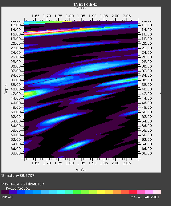
B21K Ikpikpuk River, AK, USA - Earthquake Result Viewer
| Earthquake location: |
Taiwan |
| Earthquake latitude/longitude: |
24.0/121.7 |
| Earthquake time(UTC): |
2019/04/18 (108) 05:01:06 GMT |
| Earthquake Depth: |
20 km |
| Earthquake Magnitude: |
6.1 Mww |
| Earthquake Catalog/Contributor: |
NEIC PDE/us |
|
| Network: |
TA USArray Transportable Network (new EarthScope stations) |
| Station: |
B21K Ikpikpuk River, AK, USA |
| Lat/Lon: |
69.62 N/154.61 W |
| Elevation: |
92 m |
|
| Distance: |
65.6 deg |
| Az: |
22.486 deg |
| Baz: |
272.992 deg |
| Ray Param: |
0.058175415 |
| Estimated Moho Depth: |
14.75 km |
| Estimated Crust Vp/Vs: |
1.68 |
| Assumed Crust Vp: |
6.221 km/s |
| Estimated Crust Vs: |
3.714 km/s |
| Estimated Crust Poisson's Ratio: |
0.22 |
|
| Radial Match: |
89.7707 % |
| Radial Bump: |
400 |
| Transverse Match: |
84.335396 % |
| Transverse Bump: |
400 |
| SOD ConfigId: |
13570011 |
| Insert Time: |
2019-05-02 23:12:31.067 +0000 |
| GWidth: |
2.5 |
| Max Bumps: |
400 |
| Tol: |
0.001 |
|

Signal To Noise
| Channel | StoN | STA | LTA |
| TA:B21K: :BHZ:20190418T05:11:17.399995Z | 24.886091 | 4.146887E-6 | 1.6663472E-7 |
| TA:B21K: :BHN:20190418T05:11:17.399995Z | 4.3223433 | 3.3473725E-7 | 7.744347E-8 |
| TA:B21K: :BHE:20190418T05:11:17.399995Z | 6.912564 | 7.4309276E-7 | 1.07498856E-7 |
| Arrivals |
| Ps | 1.7 SECOND |
| PpPs | 6.1 SECOND |
| PsPs/PpSs | 7.8 SECOND |


