You are here: Home > Network List > TA - USArray Transportable Network (new EarthScope stations) Stations List
> Station D25K Kavik River, AK, USA > Earthquake Result Viewer
D25K Kavik River, AK, USA - Earthquake Result Viewer
| Earthquake location: |
Taiwan |
| Earthquake latitude/longitude: |
24.0/121.7 |
| Earthquake time(UTC): |
2019/04/18 (108) 05:01:06 GMT |
| Earthquake Depth: |
20 km |
| Earthquake Magnitude: |
6.1 Mww |
| Earthquake Catalog/Contributor: |
NEIC PDE/us |
|
| Network: |
TA USArray Transportable Network (new EarthScope stations) |
| Station: |
D25K Kavik River, AK, USA |
| Lat/Lon: |
69.32 N/146.38 W |
| Elevation: |
770 m |
|
| Distance: |
68.5 deg |
| Az: |
22.434 deg |
| Baz: |
280.681 deg |
| Ray Param: |
0.056261756 |
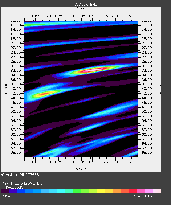
| Estimated Moho Depth: |
31.5 km |
| Estimated Crust Vp/Vs: |
1.90 |
| Assumed Crust Vp: |
6.378 km/s |
| Estimated Crust Vs: |
3.353 km/s |
| Estimated Crust Poisson's Ratio: |
0.31 |
|
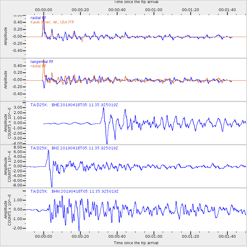
| Radial Match: |
95.877655 % |
| Radial Bump: |
400 |
| Transverse Match: |
91.687065 % |
| Transverse Bump: |
400 |
| SOD ConfigId: |
13570011 |
| Insert Time: |
2019-05-02 23:12:41.048 +0000 |
| GWidth: |
2.5 |
| Max Bumps: |
400 |
| Tol: |
0.001 |
|
Signal To Noise
| Channel | StoN | STA | LTA |
| TA:D25K: :BHZ:20190418T05:11:35.925019Z | 31.537987 | 3.9389065E-6 | 1.2489404E-7 |
| TA:D25K: :BHN:20190418T05:11:35.925019Z | 4.3556643 | 4.2357294E-7 | 9.7246456E-8 |
| TA:D25K: :BHE:20190418T05:11:35.925019Z | 19.534908 | 1.8069728E-6 | 9.249968E-8 |
| Arrivals |
| Ps | 4.6 SECOND |
| PpPs | 14 SECOND |
| PsPs/PpSs | 18 SECOND |


