You are here: Home > Network List > TA - USArray Transportable Network (new EarthScope stations) Stations List
> Station D14A Greenough, MT, USA > Earthquake Result Viewer
D14A Greenough, MT, USA - Earthquake Result Viewer

| Earthquake location: |
Eastern Honshu, Japan |
| Earthquake latitude/longitude: |
39.8/141.5 |
| Earthquake time(UTC): |
2008/07/23 (205) 15:26:19 GMT |
| Earthquake Depth: |
108 km |
| Earthquake Magnitude: |
6.6 MB, 6.8 MW, 6.8 MW |
| Earthquake Catalog/Contributor: |
WHDF/NEIC |
|
| Network: |
TA USArray Transportable Network (new EarthScope stations) |
| Station: |
D14A Greenough, MT, USA |
| Lat/Lon: |
47.08 N/113.51 W |
| Elevation: |
1444 m |
|
| Distance: |
70.8 deg |
| Az: |
44.341 deg |
| Baz: |
308.014 deg |
| Ray Param: |
0.054478396 |
| Estimated Moho Depth: |
36.25 km |
| Estimated Crust Vp/Vs: |
1.78 |
| Assumed Crust Vp: |
6.353 km/s |
| Estimated Crust Vs: |
3.574 km/s |
| Estimated Crust Poisson's Ratio: |
0.27 |
|
| Radial Match: |
96.88258 % |
| Radial Bump: |
393 |
| Transverse Match: |
91.245926 % |
| Transverse Bump: |
400 |
| SOD ConfigId: |
2504 |
| Insert Time: |
2010-03-06 21:32:52.889 +0000 |
| GWidth: |
2.5 |
| Max Bumps: |
400 |
| Tol: |
0.001 |
|
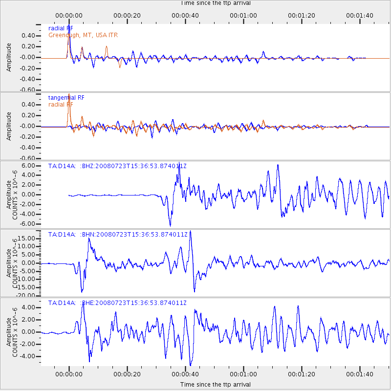
Signal To Noise
| Channel | StoN | STA | LTA |
| TA:D14A: :BHN:20080723T15:36:53.874011Z | 63.72112 | 6.561391E-6 | 1.02970425E-7 |
| TA:D14A: :BHE:20080723T15:36:53.874011Z | 33.80311 | 1.6609434E-6 | 4.913582E-8 |
| TA:D14A: :BHZ:20080723T15:36:53.874011Z | 28.158674 | 2.0281434E-6 | 7.202553E-8 |
| Arrivals |
| Ps | 4.6 SECOND |
| PpPs | 15 SECOND |
| PsPs/PpSs | 20 SECOND |


