You are here: Home > Network List > TA - USArray Transportable Network (new EarthScope stations) Stations List
> Station E20K Nigu River, AK, USA > Earthquake Result Viewer
E20K Nigu River, AK, USA - Earthquake Result Viewer
| Earthquake location: |
Taiwan |
| Earthquake latitude/longitude: |
24.0/121.7 |
| Earthquake time(UTC): |
2019/04/18 (108) 05:01:06 GMT |
| Earthquake Depth: |
20 km |
| Earthquake Magnitude: |
6.1 Mww |
| Earthquake Catalog/Contributor: |
NEIC PDE/us |
|
| Network: |
TA USArray Transportable Network (new EarthScope stations) |
| Station: |
E20K Nigu River, AK, USA |
| Lat/Lon: |
68.26 N/156.19 W |
| Elevation: |
866 m |
|
| Distance: |
65.0 deg |
| Az: |
24.021 deg |
| Baz: |
272.164 deg |
| Ray Param: |
0.058508508 |
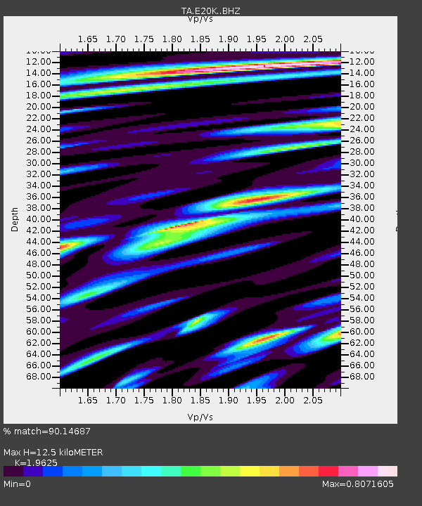
| Estimated Moho Depth: |
12.5 km |
| Estimated Crust Vp/Vs: |
1.96 |
| Assumed Crust Vp: |
6.221 km/s |
| Estimated Crust Vs: |
3.17 km/s |
| Estimated Crust Poisson's Ratio: |
0.32 |
|
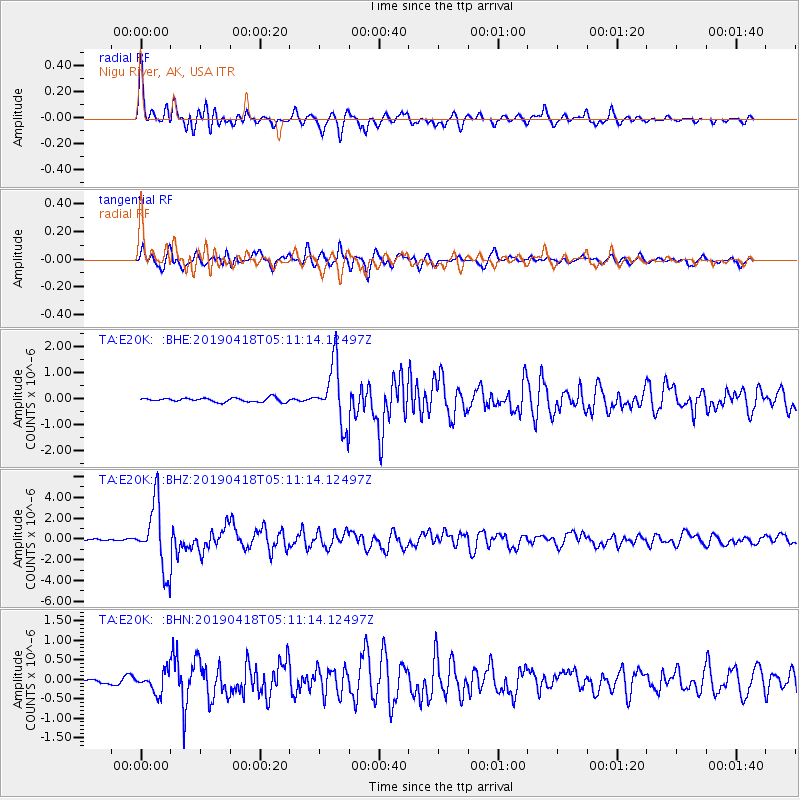
| Radial Match: |
90.14687 % |
| Radial Bump: |
400 |
| Transverse Match: |
82.56746 % |
| Transverse Bump: |
400 |
| SOD ConfigId: |
13570011 |
| Insert Time: |
2019-05-02 23:12:45.181 +0000 |
| GWidth: |
2.5 |
| Max Bumps: |
400 |
| Tol: |
0.001 |
|
Signal To Noise
| Channel | StoN | STA | LTA |
| TA:E20K: :BHZ:20190418T05:11:14.12497Z | 30.26397 | 3.1810296E-6 | 1.05109464E-7 |
| TA:E20K: :BHN:20190418T05:11:14.12497Z | 4.7230616 | 2.689101E-7 | 5.6935548E-8 |
| TA:E20K: :BHE:20190418T05:11:14.12497Z | 14.834295 | 1.1415278E-6 | 7.695194E-8 |
| Arrivals |
| Ps | 2.0 SECOND |
| PpPs | 5.7 SECOND |
| PsPs/PpSs | 7.7 SECOND |


