You are here: Home > Network List > TA - USArray Transportable Network (new EarthScope stations) Stations List
> Station F20K Avaraart Lake, AK, USA > Earthquake Result Viewer
F20K Avaraart Lake, AK, USA - Earthquake Result Viewer
| Earthquake location: |
Taiwan |
| Earthquake latitude/longitude: |
24.0/121.7 |
| Earthquake time(UTC): |
2019/04/18 (108) 05:01:06 GMT |
| Earthquake Depth: |
20 km |
| Earthquake Magnitude: |
6.1 Mww |
| Earthquake Catalog/Contributor: |
NEIC PDE/us |
|
| Network: |
TA USArray Transportable Network (new EarthScope stations) |
| Station: |
F20K Avaraart Lake, AK, USA |
| Lat/Lon: |
67.05 N/155.73 W |
| Elevation: |
136 m |
|
| Distance: |
65.3 deg |
| Az: |
25.349 deg |
| Baz: |
273.15 deg |
| Ray Param: |
0.05835532 |
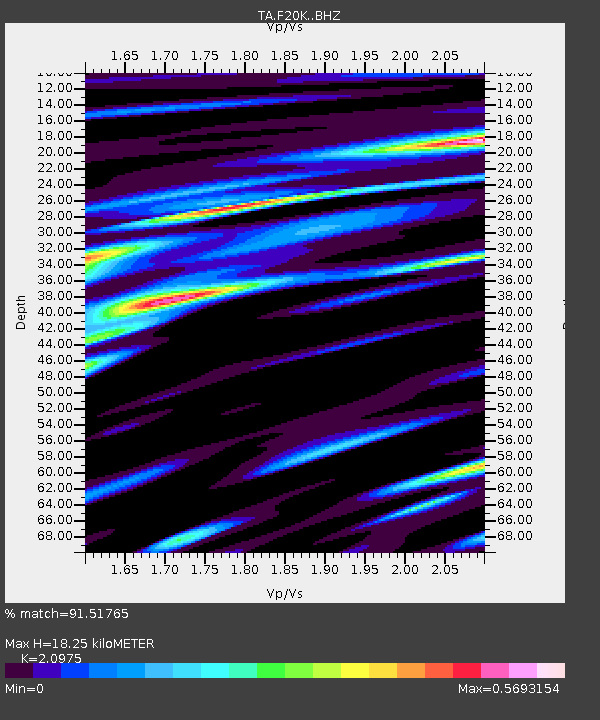
| Estimated Moho Depth: |
18.25 km |
| Estimated Crust Vp/Vs: |
2.10 |
| Assumed Crust Vp: |
6.522 km/s |
| Estimated Crust Vs: |
3.109 km/s |
| Estimated Crust Poisson's Ratio: |
0.35 |
|
| Radial Match: |
91.51765 % |
| Radial Bump: |
400 |
| Transverse Match: |
76.29152 % |
| Transverse Bump: |
400 |
| SOD ConfigId: |
13570011 |
| Insert Time: |
2019-05-02 23:12:56.000 +0000 |
| GWidth: |
2.5 |
| Max Bumps: |
400 |
| Tol: |
0.001 |
|

Signal To Noise
| Channel | StoN | STA | LTA |
| TA:F20K: :BHZ:20190418T05:11:15.649995Z | 27.357702 | 2.8861284E-6 | 1.0549601E-7 |
| TA:F20K: :BHN:20190418T05:11:15.649995Z | 1.9452417 | 2.0613562E-7 | 1.0596916E-7 |
| TA:F20K: :BHE:20190418T05:11:15.649995Z | 12.881118 | 1.3160266E-6 | 1.02167114E-7 |
| Arrivals |
| Ps | 3.2 SECOND |
| PpPs | 8.4 SECOND |
| PsPs/PpSs | 12 SECOND |


