You are here: Home > Network List > TA - USArray Transportable Network (new EarthScope stations) Stations List
> Station F18K Selawik, AK, USA > Earthquake Result Viewer
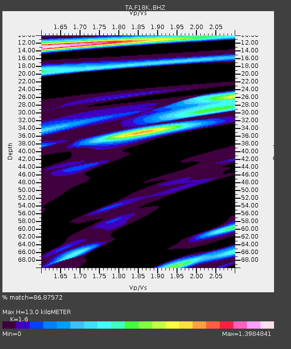
F18K Selawik, AK, USA - Earthquake Result Viewer
| Earthquake location: |
Taiwan |
| Earthquake latitude/longitude: |
24.0/121.7 |
| Earthquake time(UTC): |
2019/04/18 (108) 05:01:06 GMT |
| Earthquake Depth: |
20 km |
| Earthquake Magnitude: |
6.1 Mww |
| Earthquake Catalog/Contributor: |
NEIC PDE/us |
|
| Network: |
TA USArray Transportable Network (new EarthScope stations) |
| Station: |
F18K Selawik, AK, USA |
| Lat/Lon: |
66.60 N/159.65 W |
| Elevation: |
27 m |
|
| Distance: |
63.7 deg |
| Az: |
25.892 deg |
| Baz: |
269.778 deg |
| Ray Param: |
0.059360996 |
| Estimated Moho Depth: |
13.0 km |
| Estimated Crust Vp/Vs: |
1.60 |
| Assumed Crust Vp: |
6.577 km/s |
| Estimated Crust Vs: |
4.11 km/s |
| Estimated Crust Poisson's Ratio: |
0.18 |
|
| Radial Match: |
86.87572 % |
| Radial Bump: |
400 |
| Transverse Match: |
87.14135 % |
| Transverse Bump: |
400 |
| SOD ConfigId: |
13570011 |
| Insert Time: |
2019-05-02 23:12:57.360 +0000 |
| GWidth: |
2.5 |
| Max Bumps: |
400 |
| Tol: |
0.001 |
|

Signal To Noise
| Channel | StoN | STA | LTA |
| TA:F18K: :BHZ:20190418T05:11:05.574982Z | 32.94058 | 3.6073632E-6 | 1.0951123E-7 |
| TA:F18K: :BHN:20190418T05:11:05.574982Z | 1.0649357 | 1.8861942E-7 | 1.7711814E-7 |
| TA:F18K: :BHE:20190418T05:11:05.574982Z | 7.7495728 | 1.4956402E-6 | 1.9299645E-7 |
| Arrivals |
| Ps | 1.2 SECOND |
| PpPs | 4.9 SECOND |
| PsPs/PpSs | 6.1 SECOND |


