You are here: Home > Network List > TA - USArray Transportable Network (new EarthScope stations) Stations List
> Station G30M túh Zraii Njik, YT, CAN > Earthquake Result Viewer
G30M túh Zraii Njik, YT, CAN - Earthquake Result Viewer
| Earthquake location: |
Taiwan |
| Earthquake latitude/longitude: |
24.0/121.7 |
| Earthquake time(UTC): |
2019/04/18 (108) 05:01:06 GMT |
| Earthquake Depth: |
20 km |
| Earthquake Magnitude: |
6.1 Mww |
| Earthquake Catalog/Contributor: |
NEIC PDE/us |
|
| Network: |
TA USArray Transportable Network (new EarthScope stations) |
| Station: |
G30M túh Zraii Njik, YT, CAN |
| Lat/Lon: |
66.98 N/136.22 W |
| Elevation: |
739 m |
|
| Distance: |
72.8 deg |
| Az: |
23.744 deg |
| Baz: |
290.537 deg |
| Ray Param: |
0.053430658 |
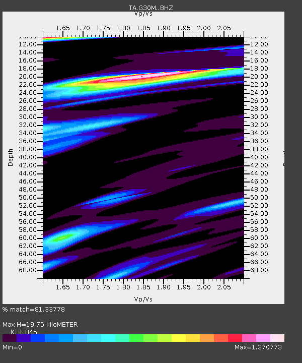
| Estimated Moho Depth: |
19.75 km |
| Estimated Crust Vp/Vs: |
1.85 |
| Assumed Crust Vp: |
6.522 km/s |
| Estimated Crust Vs: |
3.535 km/s |
| Estimated Crust Poisson's Ratio: |
0.29 |
|
| Radial Match: |
81.33778 % |
| Radial Bump: |
400 |
| Transverse Match: |
71.67833 % |
| Transverse Bump: |
400 |
| SOD ConfigId: |
13570011 |
| Insert Time: |
2019-05-02 23:13:35.817 +0000 |
| GWidth: |
2.5 |
| Max Bumps: |
400 |
| Tol: |
0.001 |
|

Signal To Noise
| Channel | StoN | STA | LTA |
| TA:G30M: :BHZ:20190418T05:12:01.975007Z | 14.022182 | 2.4130386E-6 | 1.7208724E-7 |
| TA:G30M: :BHN:20190418T05:12:01.975007Z | 2.5123787 | 3.8531405E-7 | 1.5336623E-7 |
| TA:G30M: :BHE:20190418T05:12:01.975007Z | 7.921563 | 9.033632E-7 | 1.140385E-7 |
| Arrivals |
| Ps | 2.6 SECOND |
| PpPs | 8.3 SECOND |
| PsPs/PpSs | 11 SECOND |


